La Plata geodata
La Plata (Buenos Aires) is a seat of a first-order administrative division; located in Argentina in America/Argentina/Buenos_Aires (GMT-3) time zone. With population of 694,167 people, there are 5 cities with bigger population in this country. Compared to other cities in Argentina, 77.1% of cities are located further ↑North; 89.3% of cities are located further ←West and 91% of cities have higher elevation than La Plata. Note1


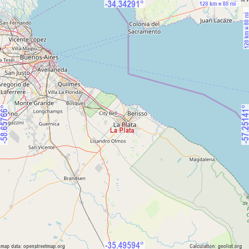
La Plata GPS coordinates[2]
34° 55' 17.22" South, 57° 57' 16.308" West
| Map corner | latitude | longitude |
|---|---|---|
| Upper-left | -34.34291°, | -58.65766° |
| Center: | -34.92145°, | -57.95453° |
| Lower-right: | -35.49594°, | -57.25141° |
| Map W x H: | 128.2×128.2 km | = 79.7×79.7mi |
| max Lat: | -21.94467° ⇑77.1% North |
| La Plata: | -34.92145° |
| min Lat: | ⇓22.9% South -54.81084° |
| min Long | La Plata | max Long |
| -72.88605° | -57.95453° | -53.64581° |
| W 89.3%⇐ | ⇒10.7% E |
Elevation
Elevation of La Plata is 27 m = 89 ft, and this is 322.3 m = 1057 ft below average elevation for this country.
| Max E: |
4040 m = 13255 ft | 91% |
| Avg. | 349.3 m = 1146 ft | |
| La Plata | 27 m = 89 ft | |
Min E: |
-2 m = -7 ft | 9% |
See also: La Plata elevation on elevation.city.
Geographical zone
La Plata is located in South temperate zone (between Tropic of Capricorn and the Antarctic Circle). Distance of this Southern Tropic circle is 1277 km =793.5 mi to North.| Distance of | km | miles | from La Plata |
|---|---|---|---|
| Equator | 3882.9 | 2412.7 | to North |
| Tropic Capricorn | 1277 | 793.5 | to North |
| Antarctic Circle | 3518.3 | 2186.2 | to South |
| South Pole | 6124.2 | 3805.4 | to South |


Nearby cities:
15 places around La Plata: (largest is in red/bold)
• Adrogué
41.4 km =25.7 mi,  288°
288°
• Avellaneda
47.6 km =29.6 mi,  307°
307°
• Barracas
49.5 km =30.8 mi, 307°
• Berazategui
29.3 km =18.2 mi, 306°
• Berisso
8.4 km =5.2 mi,  50°
50°
• Brandsen
37.5 km =23.3 mi,  222°
222°
• Buenos Aires
51.6 km =32.1 mi, 311°
• Ensenada
7.7 km =4.8 mi,  30°
30°
• Florencio Varela
41.6 km =25.8 mi,  284°
284°
• Guernica
38.9 km =24.2 mi,  270°
270°
• Lanús
47 km =29.2 mi,  301°
301°
• Lomas de Zamora
44.9 km =27.9 mi, 293°
• Magdalena
43.9 km =27.3 mi,  113°
113°
• Quilmes
35.4 km =22 mi, 307°
• San Vicente
44.3 km =27.5 mi,  254°
254°
Sources, notices
• [Note1] Compared only with cities in Argentina existing in our database
• [Src1] Map data: © OpenStreetMap contributors (CC-BY-SA)
• [Src2] Other city data from geonames.org with taken over terms of usage.
• [Src3] Geographical zone / Annual Mean Temperature by Robert A. Rohde @ Wikipedia
