Florentino Ameghino geodata
Florentino Ameghino (Misiones) is a populated place; located in Argentina in America/Argentina/Cordoba (GMT-3) time zone. With population of 1,979 people, there are 648 cities with bigger population in this country. Compared to other cities in Argentina, 79.4% of cities are located further ↓South; 97.1% of cities are located further ←West and 63.7% of cities have lower elevation than Florentino Ameghino. Note1


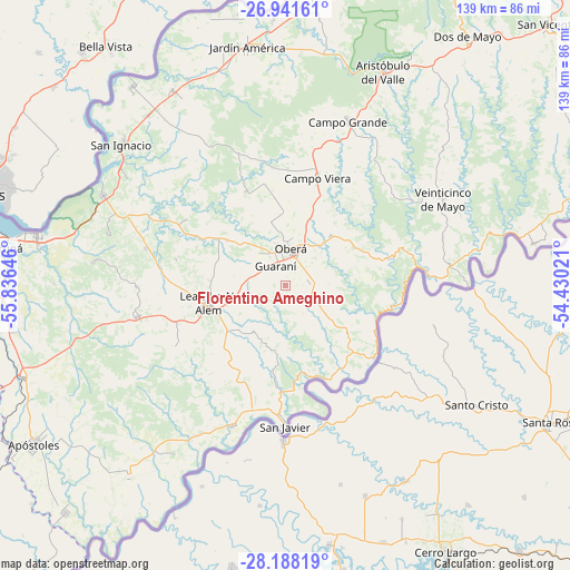
Florentino Ameghino GPS coordinates[2]
27° 34' 0.012" South, 55° 7' 59.988" West
| Map corner | latitude | longitude |
|---|---|---|
| Upper-left | -26.94161°, | -55.83646° |
| Center: | -27.56667°, | -55.13333° |
| Lower-right: | -28.18819°, | -54.43021° |
| Map W x H: | 138.6×138.6 km | = 86.1×86.1mi |
| max Lat: | -21.94467° ⇑20.6% North |
| Florentino Ameghino: | -27.56667° |
| min Lat: | ⇓79.4% South -54.81084° |
| min Long | Florentino Ameg | max Long |
| -72.88605° | -55.13333° | -53.64581° |
| W 97.1%⇐ | ⇒2.9% E |
Elevation
Elevation of Florentino Ameghino is 252 m = 827 ft, and this is 97.3 m = 319 ft below average elevation for this country.
| Max E: |
4040 m = 13255 ft | 36.3% |
| Avg. | 349.3 m = 1146 ft | |
| Florentino Ameghino | 252 m = 827 ft | |
Min E: |
-2 m = -7 ft | 63.7% |
See also: Argentina elevation on elevation.city.
Geographical zone
Florentino Ameghino is located in South temperate zone (between Tropic of Capricorn and the Antarctic Circle). Distance of this Southern Tropic circle is 459.2 km =285.3 mi to North.| Distance of | km | miles | from Florentino Ameghino |
|---|---|---|---|
| Equator | 3065.1 | 1904.6 | to North |
| Tropic Capricorn | 459.2 | 285.3 | to North |
| Antarctic Circle | 4336 | 2694.3 | to South |
| South Pole | 6941.9 | 4313.5 | to South |


Nearby cities:
15 places around Florentino Ameghino: (largest is in red/bold)
• Almafuerte
27.3 km =17 mi,  283°
283°
• Arroyo del Medio
30.4 km =18.9 mi,  241°
241°
• Campo Ramón
16.6 km =10.3 mi,  41°
41°
• Campo Viera
27.1 km =16.8 mi,  16°
16°
• Dos Arroyos
18.8 km =11.7 mi,  218°
218°
• General Alvear
16 km =9.9 mi,  347°
347°
• Guaraní
5.5 km =3.4 mi,  330°
330°
• Leandro N. Alem
19.3 km =12 mi,  257°
257°
• Los Helechos
5.6 km =3.5 mi,  71°
71°
• Mojón Grande
16.3 km =10.1 mi,  187°
187°
• Mártires
28.8 km =17.9 mi,  303°
303°
• Oberá
8.9 km =5.5 mi,  8°
8°
• Panambí
27.7 km =17.2 mi,  129°
129°
• Picada Gobernador López
16 km =9.9 mi, 223°
• San Javier
34.2 km =21.3 mi,  180°
180°
Sources, notices
• [Note1] Compared only with cities in Argentina existing in our database
• [Src1] Map data: © OpenStreetMap contributors (CC-BY-SA)
• [Src2] Other city data from geonames.org with taken over terms of usage.
• [Src3] Geographical zone / Annual Mean Temperature by Robert A. Rohde @ Wikipedia
