Mártires geodata
Mártires (Misiones) is a populated place; located in Argentina in America/Argentina/Cordoba (GMT-3) time zone. With population of 1,135 people, there are 750 cities with bigger population in this country. Compared to other cities in Argentina, 82% of cities are located further ↓South; 96.1% of cities are located further ←West and 54.7% of cities have lower elevation than Mártires. Note1


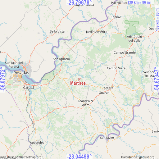
Mártires GPS coordinates[2]
27° 25' 21.54" South, 55° 22' 35.724" West
| Map corner | latitude | longitude |
|---|---|---|
| Upper-left | -26.79678°, | -56.07972° |
| Center: | -27.42265°, | -55.37659° |
| Lower-right: | -28.04499°, | -54.67347° |
| Map W x H: | 138.8×138.8 km | = 86.2×86.2mi |
| max Lat: | -21.94467° ⇑18% North |
| Mártires: | -27.42265° |
| min Lat: | ⇓82% South -54.81084° |
| min Long | Mártires | max Long |
| -72.88605° | -55.37659° | -53.64581° |
| W 96.1%⇐ | ⇒3.9% E |
Elevation
Elevation of Mártires is 171 m = 561 ft, and this is 178.3 m = 585 ft below average elevation for this country.
| Max E: |
4040 m = 13255 ft | 45.3% |
| Avg. | 349.3 m = 1146 ft | |
| Mártires | 171 m = 561 ft | |
Min E: |
-2 m = -7 ft | 54.7% |
See also: Argentina elevation on elevation.city.
Geographical zone
Mártires is located in South temperate zone (between Tropic of Capricorn and the Antarctic Circle). Distance of this Southern Tropic circle is 443.2 km =275.4 mi to North.| Distance of | km | miles | from Mártires |
|---|---|---|---|
| Equator | 3049.1 | 1894.6 | to North |
| Tropic Capricorn | 443.2 | 275.4 | to North |
| Antarctic Circle | 4352.1 | 2704.3 | to South |
| South Pole | 6957.9 | 4323.4 | to South |


Nearby cities:
15 places around Mártires: (largest is in red/bold)
• Almafuerte
9.9 km =6.2 mi,  195°
195°
• Arroyo del Medio
30.7 km =19.1 mi,  185°
185°
• Bonpland
12 km =7.5 mi,  236°
236°
• Cerro Azul
26.2 km =16.3 mi,  206°
206°
• Cerro Corá
25 km =15.5 mi,  246°
246°
• Florentino Ameghino
28.8 km =17.9 mi,  123°
123°
• General Alvear
20.5 km =12.7 mi,  91°
91°
• Gobernador Roca
27.7 km =17.2 mi,  341°
341°
• Guaraní
24 km =14.9 mi, 117°
• Leandro N. Alem
20.7 km =12.9 mi,  165°
165°
• Loreto
17.8 km =11.1 mi,  304°
304°
• Oberá
26.3 km =16.3 mi,  105°
105°
• Picada Gobernador López
30.4 km =18.9 mi,  154°
154°
• San Ignacio
24.2 km =15 mi,  320°
320°
• Santa Ana
21.1 km =13.1 mi,  286°
286°
Sources, notices
• [Note1] Compared only with cities in Argentina existing in our database
• [Src1] Map data: © OpenStreetMap contributors (CC-BY-SA)
• [Src2] Other city data from geonames.org with taken over terms of usage.
• [Src3] Geographical zone / Annual Mean Temperature by Robert A. Rohde @ Wikipedia
