Tilcara geodata
Tilcara (Jujuy) is a seat of a second-order administrative division; located in Argentina in America/Argentina/Jujuy (GMT-3) time zone. With population of 5,640 people, there are 412 cities with bigger population in this country. Compared to other cities in Argentina, 98.5% of cities are located further ↓South; 76.8% of cities are located further →East and 99.1% of cities have lower elevation than Tilcara. Note1


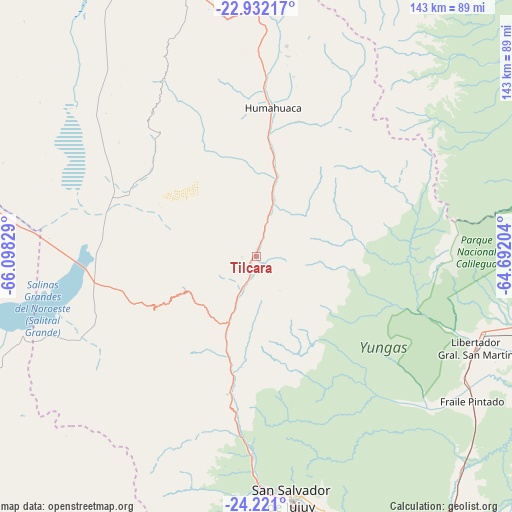
Tilcara GPS coordinates[2]
23° 34' 41.412" South, 65° 23' 42.576" West
| Map corner | latitude | longitude |
|---|---|---|
| Upper-left | -22.93217°, | -66.09829° |
| Center: | -23.57817°, | -65.39516° |
| Lower-right: | -24.221°, | -64.69204° |
| Map W x H: | 143.3×143.3 km | = 89×89mi |
| max Lat: | -21.94467° ⇑1.5% North |
| Tilcara: | -23.57817° |
| min Lat: | ⇓98.5% South -54.81084° |
| min Long | Tilcara | max Long |
| -72.88605° | -65.39516° | -53.64581° |
| W 23.2%⇐ | ⇒76.8% E |
Elevation
Elevation of Tilcara is 3180 m = 10433 ft, and this is 2830.7 m = 9287 ft above average elevation for this country.
| Max E: |
4040 m = 13255 ft | 0.90000000000001% |
| Tilcara | 3180 m 10433 ft | |
| Avg. | 349.3 m = 1146 ft | |
Min E: |
-2 m = -7 ft | 99.1% |
See also: Argentina elevation on elevation.city.
Geographical zone
Tilcara is located in South temperate zone (between Tropic of Capricorn and the Antarctic Circle). Distance of this Southern Tropic circle is 15.7 km =9.8 mi to North.| Distance of | km | miles | from Tilcara |
|---|---|---|---|
| Equator | 2621.6 | 1629 | to North |
| Tropic Capricorn | 15.7 | 9.8 | to North |
| Antarctic Circle | 4779.5 | 2969.8 | to South |
| South Pole | 7385.4 | 4589.1 | to South |


Nearby cities:
15 places around Tilcara: (largest is in red/bold)
• Caimancito
83.6 km =51.9 mi,  102°
102°
• Calilegua
67.3 km =41.8 mi,  108°
108°
• El Aguilar
49.7 km =30.9 mi,  324°
324°
• El Carmen
90.9 km =56.5 mi,  171°
171°
• Fraile Pintado
72.8 km =45.2 mi,  123°
123°
• Humahuaca
41.7 km =25.9 mi,  6°
6°
• Iruya
89.3 km =55.5 mi, 11°
• Libertador General San Martín
66.9 km =41.6 mi, 112°
• Maimará
5.3 km =3.3 mi,  194°
194°
• Palpalá
77.7 km =48.3 mi, 166°
• San Antonio
88 km =54.7 mi,  175°
175°
• San Pedro de Jujuy
90.4 km =56.2 mi,  143°
143°
• San Salvador de Jujuy
69.3 km =43.1 mi, 171°
• Tumbaya
32 km =19.9 mi, 193°
• Valle Grande
47 km =29.2 mi,  76°
76°
Sources, notices
• [Note1] Compared only with cities in Argentina existing in our database
• [Src1] Map data: © OpenStreetMap contributors (CC-BY-SA)
• [Src2] Other city data from geonames.org with taken over terms of usage.
• [Src3] Geographical zone / Annual Mean Temperature by Robert A. Rohde @ Wikipedia
