Calilegua geodata
Calilegua (Jujuy) is a populated place; located in Argentina in America/Argentina/Jujuy (GMT-3) time zone. With population of 5,174 people, there are 438 cities with bigger population in this country. Compared to other cities in Argentina, 98.1% of cities are located further ↓South; 70.6% of cities are located further →East and 75.9% of cities have lower elevation than Calilegua. Note1


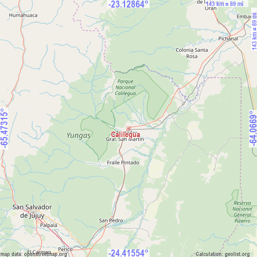
Calilegua GPS coordinates[2]
23° 46' 25.248" South, 64° 46' 12.072" West
| Map corner | latitude | longitude |
|---|---|---|
| Upper-left | -23.12864°, | -65.47315° |
| Center: | -23.77368°, | -64.77002° |
| Lower-right: | -24.41554°, | -64.0669° |
| Map W x H: | 143.1×143.1 km | = 88.9×88.9mi |
| max Lat: | -21.94467° ⇑1.9% North |
| Calilegua: | -23.77368° |
| min Lat: | ⇓98.1% South -54.81084° |
| min Long | Calilegua | max Long |
| -72.88605° | -64.77002° | -53.64581° |
| W 29.4%⇐ | ⇒70.6% E |
Elevation
Elevation of Calilegua is 468 m = 1535 ft, and this is 118.7 m = 389 ft above average elevation for this country.
| Max E: |
4040 m = 13255 ft | 24.1% |
| Calilegua | 468 m 1535 ft | |
| Avg. | 349.3 m = 1146 ft | |
Min E: |
-2 m = -7 ft | 75.9% |
See also: Argentina elevation on elevation.city.
Geographical zone
Calilegua is located in South temperate zone (between Tropic of Capricorn and the Antarctic Circle). Distance of this Southern Tropic circle is 37.5 km =23.3 mi to North.| Distance of | km | miles | from Calilegua |
|---|---|---|---|
| Equator | 2643.4 | 1642.5 | to North |
| Tropic Capricorn | 37.5 | 23.3 | to North |
| Antarctic Circle | 4757.8 | 2956.4 | to South |
| South Pole | 7363.7 | 4575.6 | to South |


Nearby cities:
15 places around Calilegua: (largest is in red/bold)
• Caimancito
18.3 km =11.4 mi,  78°
78°
• Fraile Pintado
18.8 km =11.7 mi,  189°
189°
• Ingenio La Esperanza
50.7 km =31.5 mi, 187°
• La Mendieta
63 km =39.1 mi,  198°
198°
• Libertador General San Martín
4.1 km =2.5 mi,  206°
206°
• Maimará
67.1 km =41.7 mi,  284°
284°
• Palma Sola
52.6 km =32.7 mi,  115°
115°
• Palpalá
70 km =43.5 mi,  219°
219°
• San Pedro de Jujuy
51.8 km =32.2 mi, 190°
• San Salvador de Jujuy
71.1 km =44.2 mi,  228°
228°
• Santa Clara
60.5 km =37.6 mi,  169°
169°
• Tilcara
67.3 km =41.8 mi,  288°
288°
• Tumbaya
71.5 km =44.4 mi,  262°
262°
• Valle Grande
37.7 km =23.4 mi,  331°
331°
• Yuto
33.6 km =20.9 mi,  64°
64°
Sources, notices
• [Note1] Compared only with cities in Argentina existing in our database
• [Src1] Map data: © OpenStreetMap contributors (CC-BY-SA)
• [Src2] Other city data from geonames.org with taken over terms of usage.
• [Src3] Geographical zone / Annual Mean Temperature by Robert A. Rohde @ Wikipedia
