Obispo Trejo geodata
Obispo Trejo (Cordoba) is a populated place; located in Argentina in America/Argentina/Cordoba (GMT-3) time zone. With population of 1,911 people, there are 654 cities with bigger population in this country. Compared to other cities in Argentina, 61.6% of cities are located further ↓South; 54.7% of cities are located further →East and 61.7% of cities have higher elevation than Obispo Trejo. Note1


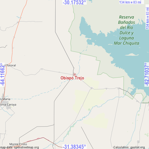
Obispo Trejo GPS coordinates[2]
30° 46' 52.608" South, 63° 24' 48.564" West
| Map corner | latitude | longitude |
|---|---|---|
| Upper-left | -30.17532°, | -64.11662° |
| Center: | -30.78128°, | -63.41349° |
| Lower-right: | -31.38345°, | -62.71037° |
| Map W x H: | 134.3×134.3 km | = 83.5×83.5mi |
| max Lat: | -21.94467° ⇑38.4% North |
| Obispo Trejo: | -30.78128° |
| min Lat: | ⇓61.6% South -54.81084° |
| min Long | Obispo Trejo | max Long |
| -72.88605° | -63.41349° | -53.64581° |
| W 45.3%⇐ | ⇒54.7% E |
Elevation
Elevation of Obispo Trejo is 103 m = 338 ft, and this is 246.3 m = 808 ft below average elevation for this country.
| Max E: |
4040 m = 13255 ft | 61.7% |
| Avg. | 349.3 m = 1146 ft | |
| Obispo Trejo | 103 m = 338 ft | |
Min E: |
-2 m = -7 ft | 38.3% |
See also: Argentina elevation on elevation.city.
Geographical zone
Obispo Trejo is located in South temperate zone (between Tropic of Capricorn and the Antarctic Circle). Distance of this Southern Tropic circle is 816.6 km =507.4 mi to North.| Distance of | km | miles | from Obispo Trejo |
|---|---|---|---|
| Equator | 3422.6 | 2126.7 | to North |
| Tropic Capricorn | 816.6 | 507.4 | to North |
| Antarctic Circle | 3978.6 | 2472.2 | to South |
| South Pole | 6584.5 | 4091.4 | to South |


Nearby cities:
15 places around Obispo Trejo: (largest is in red/bold)
• Arroyito
79 km =49.1 mi,  154°
154°
• Balnearia
75.6 km =47 mi,  109°
109°
• Cañada de Luque
30.1 km =18.7 mi,  280°
280°
• Colonia La Tordilla
60.8 km =37.8 mi, 146°
• Jesús María
68.7 km =42.7 mi,  251°
251°
• La Para
41.3 km =25.7 mi, 107°
• Marull
60.9 km =37.8 mi, 112°
• Miramar
71.8 km =44.6 mi,  102°
102°
• Piquillín
66.5 km =41.3 mi,  209°
209°
• San José de la Dormida
69.8 km =43.4 mi,  312°
312°
• Santa Rosa de Río Primero
41.3 km =25.7 mi,  178°
178°
• Santiago Temple
67.4 km =41.9 mi, 180°
• Sebastián Elcano
71.1 km =44.2 mi,  345°
345°
• Villa Tulumba
80.3 km =49.9 mi,  302°
302°
• Villa del Totoral
29.2 km =18.1 mi,  262°
262°
Sources, notices
• [Note1] Compared only with cities in Argentina existing in our database
• [Src1] Map data: © OpenStreetMap contributors (CC-BY-SA)
• [Src2] Other city data from geonames.org with taken over terms of usage.
• [Src3] Geographical zone / Annual Mean Temperature by Robert A. Rohde @ Wikipedia
