Miramar geodata
Miramar (Cordoba) is a populated place; located in Argentina in America/Argentina/Cordoba (GMT-3) time zone. With population of 1,979 people, there are 648 cities with bigger population in this country. Compared to other cities in Argentina, 60.6% of cities are located further ↓South; 51% of cities are located further ←West and 70.9% of cities have higher elevation than Miramar. Note1


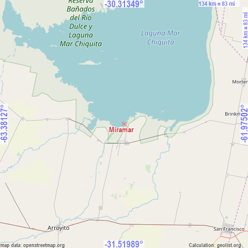
Miramar GPS coordinates[2]
30° 55' 6.924" South, 62° 40' 41.304" West
| Map corner | latitude | longitude |
|---|---|---|
| Upper-left | -30.31349°, | -63.38127° |
| Center: | -30.91859°, | -62.67814° |
| Lower-right: | -31.51989°, | -61.97502° |
| Map W x H: | 134.1×134.1 km | = 83.3×83.3mi |
| max Lat: | -21.94467° ⇑39.4% North |
| Miramar: | -30.91859° |
| min Lat: | ⇓60.6% South -54.81084° |
| min Long | Miramar | max Long |
| -72.88605° | -62.67814° | -53.64581° |
| W 51%⇐ | ⇒49% E |
Elevation
Elevation of Miramar is 78 m = 256 ft, and this is 271.3 m = 890 ft below average elevation for this country.
| Max E: |
4040 m = 13255 ft | 70.9% |
| Avg. | 349.3 m = 1146 ft | |
| Miramar | 78 m = 256 ft | |
Min E: |
-2 m = -7 ft | 29.1% |
See also: Argentina elevation on elevation.city.
Geographical zone
Miramar is located in South temperate zone (between Tropic of Capricorn and the Antarctic Circle). Distance of this Southern Tropic circle is 831.9 km =516.9 mi to North.| Distance of | km | miles | from Miramar |
|---|---|---|---|
| Equator | 3437.8 | 2136.1 | to North |
| Tropic Capricorn | 831.9 | 516.9 | to North |
| Antarctic Circle | 3963.3 | 2462.7 | to South |
| South Pole | 6569.2 | 4081.9 | to South |


Nearby cities:
15 places around Miramar: (largest is in red/bold)
• Altos de Chipión
32.8 km =20.4 mi,  97°
97°
• Arroyito
66.1 km =41.1 mi,  212°
212°
• Balnearia
10.1 km =6.3 mi,  174°
174°
• Brinkmann
61.4 km =38.2 mi,  84°
84°
• Colonia La Tordilla
50.9 km =31.6 mi,  225°
225°
• Colonia San Bartolomé
67.9 km =42.2 mi,  183°
183°
• Devoto
64.6 km =40.1 mi,  146°
146°
• El Tío
53.7 km =33.4 mi,  195°
195°
• La Francia
54.4 km =33.8 mi, 175°
• La Para
30.9 km =19.2 mi,  275°
275°
• Marull
16.4 km =10.2 mi,  238°
238°
• Morteros
68.8 km =42.8 mi,  70°
70°
• Obispo Trejo
71.8 km =44.6 mi, 282°
• Porteña
59.3 km =36.8 mi, 100°
• Villa Concepción del Tío
46.7 km =29 mi, 196°
Sources, notices
• [Note1] Compared only with cities in Argentina existing in our database
• [Src1] Map data: © OpenStreetMap contributors (CC-BY-SA)
• [Src2] Other city data from geonames.org with taken over terms of usage.
• [Src3] Geographical zone / Annual Mean Temperature by Robert A. Rohde @ Wikipedia
