Deán Funes geodata
Deán Funes (Cordoba) is a seat of a second-order administrative division; located in Argentina in America/Argentina/Cordoba (GMT-3) time zone. With population of 20,164 people, there are 183 cities with bigger population in this country. Compared to other cities in Argentina, 63.2% of cities are located further ↓South; 66% of cities are located further →East and 84.9% of cities have lower elevation than Deán Funes. Note1


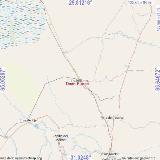
Deán Funes GPS coordinates[2]
30° 25' 13.296" South, 64° 20' 59.424" West
| Map corner | latitude | longitude |
|---|---|---|
| Upper-left | -29.81216°, | -65.05297° |
| Center: | -30.42036°, | -64.34984° |
| Lower-right: | -31.0248°, | -63.64672° |
| Map W x H: | 134.8×134.8 km | = 83.8×83.8mi |
| max Lat: | -21.94467° ⇑36.8% North |
| Deán Funes: | -30.42036° |
| min Lat: | ⇓63.2% South -54.81084° |
| min Long | Deán Funes | max Long |
| -72.88605° | -64.34984° | -53.64581° |
| W 34%⇐ | ⇒66% E |
Elevation
Elevation of Deán Funes is 691 m = 2267 ft, and this is 341.7 m = 1121 ft above average elevation for this country.
| Max E: |
4040 m = 13255 ft | 15.1% |
| Deán Funes | 691 m 2267 ft | |
| Avg. | 349.3 m = 1146 ft | |
Min E: |
-2 m = -7 ft | 84.9% |
See also: Argentina elevation on elevation.city.
Geographical zone
Deán Funes is located in South temperate zone (between Tropic of Capricorn and the Antarctic Circle). Distance of this Southern Tropic circle is 776.5 km =482.5 mi to North.| Distance of | km | miles | from Deán Funes |
|---|---|---|---|
| Equator | 3382.4 | 2101.7 | to North |
| Tropic Capricorn | 776.5 | 482.5 | to North |
| Antarctic Circle | 4018.7 | 2497.1 | to South |
| South Pole | 6624.6 | 4116.3 | to South |


Nearby cities:
15 places around Deán Funes: (largest is in red/bold)
• Agua de Oro
72 km =44.7 mi,  176°
176°
• Capilla del Monte
51.8 km =32.2 mi,  198°
198°
• Cañada de Luque
69.3 km =43.1 mi,  120°
120°
• Cruz del Eje
55.2 km =34.3 mi,  231°
231°
• Huerta Grande
74 km =46 mi,  190°
190°
• Jesús María
67 km =41.6 mi,  158°
158°
• La Cumbre
63.9 km =39.7 mi, 192°
• La Falda
75.5 km =46.9 mi, 190°
• La Granja
65.9 km =40.9 mi,  173°
173°
• Los Cocos
58 km =36 mi, 194°
• Quilino
27.1 km =16.8 mi,  327°
327°
• San José de la Dormida
39.2 km =24.4 mi,  79°
79°
• Villa Giardino
69.3 km =43.1 mi, 190°
• Villa Tulumba
22 km =13.7 mi, 82°
• Villa del Totoral
74.9 km =46.5 mi,  126°
126°
Sources, notices
• [Note1] Compared only with cities in Argentina existing in our database
• [Src1] Map data: © OpenStreetMap contributors (CC-BY-SA)
• [Src2] Other city data from geonames.org with taken over terms of usage.
• [Src3] Geographical zone / Annual Mean Temperature by Robert A. Rohde @ Wikipedia
