Agua de Oro geodata
Agua de Oro (Cordoba) is a populated place; located in Argentina in America/Argentina/Cordoba (GMT-3) time zone. With population of 1,553 people, there are 690 cities with bigger population in this country. Compared to other cities in Argentina, 59% of cities are located further ↓South; 65.1% of cities are located further →East and 88.1% of cities have lower elevation than Agua de Oro. Note1


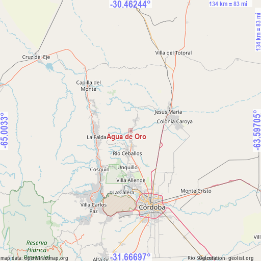
Agua de Oro GPS coordinates[2]
31° 3' 59.796" South, 64° 18' 0.612" West
| Map corner | latitude | longitude |
|---|---|---|
| Upper-left | -30.46244°, | -65.0033° |
| Center: | -31.06661°, | -64.30017° |
| Lower-right: | -31.66697°, | -63.59705° |
| Map W x H: | 133.9×133.9 km | = 83.2×83.2mi |
| max Lat: | -21.94467° ⇑41% North |
| Agua de Oro: | -31.06661° |
| min Lat: | ⇓59% South -54.81084° |
| min Long | Agua de Oro | max Long |
| -72.88605° | -64.30017° | -53.64581° |
| W 34.9%⇐ | ⇒65.1% E |
Elevation
Elevation of Agua de Oro is 791 m = 2595 ft, and this is 441.7 m = 1449 ft above average elevation for this country.
| Max E: |
4040 m = 13255 ft | 11.9% |
| Agua de Oro | 791 m 2595 ft | |
| Avg. | 349.3 m = 1146 ft | |
Min E: |
-2 m = -7 ft | 88.1% |
See also: Argentina elevation on elevation.city.
Geographical zone
Agua de Oro is located in South temperate zone (between Tropic of Capricorn and the Antarctic Circle). Distance of this Southern Tropic circle is 848.4 km =527.2 mi to North.| Distance of | km | miles | from Agua de Oro |
|---|---|---|---|
| Equator | 3454.3 | 2146.4 | to North |
| Tropic Capricorn | 848.4 | 527.2 | to North |
| Antarctic Circle | 3946.9 | 2452.5 | to South |
| South Pole | 6552.8 | 4071.7 | to South |


Nearby cities:
15 places around Agua de Oro: (largest is in red/bold)
• Cosquín
25.3 km =15.7 mi,  218°
218°
• Huerta Grande
18.2 km =11.3 mi,  266°
266°
• Jesús María
21.8 km =13.5 mi,  64°
64°
• La Cumbre
20.5 km =12.7 mi,  297°
297°
• La Falda
18.2 km =11.3 mi,  262°
262°
• La Granja
7.1 km =4.4 mi,  25°
25°
• Los Cocos
24.9 km =15.5 mi,  309°
309°
• Mendiolaza
22.3 km =13.9 mi,  180°
180°
• Río Ceballos
11.1 km =6.9 mi,  190°
190°
• Saldán
26.2 km =16.3 mi, 181°
• Salsipuedes
7.9 km =4.9 mi, 177°
• Unquillo
18.3 km =11.4 mi, 184°
• Valle Hermoso
18.1 km =11.2 mi,  251°
251°
• Villa Allende
25.4 km =15.8 mi, 178°
• Villa Giardino
17.8 km =11.1 mi,  281°
281°
Sources, notices
• [Note1] Compared only with cities in Argentina existing in our database
• [Src1] Map data: © OpenStreetMap contributors (CC-BY-SA)
• [Src2] Other city data from geonames.org with taken over terms of usage.
• [Src3] Geographical zone / Annual Mean Temperature by Robert A. Rohde @ Wikipedia
