Zistersdorf geodata
Zistersdorf (Lower Austria) is a seat of a third-order administrative division; located in Austria in Europe/Vienna (GMT+2) time zone. With population of 2,792 people, there are 416 cities with bigger population in this country. Compared to other cities in Austria, 95.3% of cities are located further ↓South; 97.9% of cities are located further ←West and 93.6% of cities have higher elevation than Zistersdorf. Note1
Administrative division(s):
- Level 1: Lower Austria
- Level 2: Politischer Bezirk Gänserndorf
- Level 3: Zistersdorf


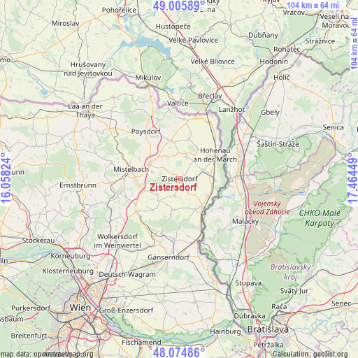
Zistersdorf GPS coordinates[2]
48° 32' 33.072" North, 16° 45' 40.896" East
| Map corner | latitude | longitude |
|---|---|---|
| Upper-left | 49.00589°, | 16.05824° |
| Center: | 48.54252°, | 16.76136° |
| Lower-right: | 48.07486°, | 17.46449° |
| Map W x H: | 103.5×103.5 km | = 64.3×64.3mi |
| max Lat: | 48.98333° ⇑4.7% North |
| Zistersdorf: | 48.54252° |
| min Lat: | ⇓95.3% South 46.48841° |
| min Long | Zistersdorf | max Long |
| 9.57802° | 16.76136° | 17.1° |
| W 97.9%⇐ | ⇒2.1% E |
Elevation
Elevation of Zistersdorf is 188 m = 617 ft, and this is 317.5 m = 1042 ft below average elevation for this country.
| Max E: |
2140 m = 7021 ft | 93.6% |
| Avg. | 505.5 m = 1658 ft | |
| Zistersdorf | 188 m = 617 ft | |
Min E: |
118 m = 387 ft | 6.4% |
See also: Austria elevation on elevation.city.
Geographical zone
Zistersdorf is located in North temperate zone (between Tropic of Cancer and the Arctic Circle). Distance of this North polar circle is 2003.8 km =1245.1 mi to North.| Distance of | km | miles | from Zistersdorf |
|---|---|---|---|
| North Pole | 4609.6 | 2864.3 | to North |
| Arctic Circle | 2003.8 | 1245.1 | to North |
| Tropic Cancer | 2791.5 | 1734.6 | to South |
| Equator | 5397.4 | 3353.8 | to South |


Nearby cities:
15 places around Zistersdorf: (largest is in red/bold)
• Bullendorf
8.3 km =5.2 mi,  303°
303°
• Dobermannsdorf
7.6 km =4.7 mi,  32°
32°
• Dürnkrut
10.1 km =6.3 mi,  139°
139°
• Groß-Inzersdorf
1.8 km =1.1 mi,  182°
182°
• Hauskirchen
6.4 km =4 mi,  3°
3°
• Jedenspeigen
9.5 km =5.9 mi,  121°
121°
• Kettlasbrunn
8.2 km =5.1 mi,  275°
275°
• Loidesthal
6.6 km =4.1 mi,  187°
187°
• Neusiedl an der Zaya
6.4 km =4 mi,  12°
12°
• Niederabsdorf
7.1 km =4.4 mi,  67°
67°
• Obersulz
8.4 km =5.2 mi,  235°
235°
• Palterndorf
6.1 km =3.8 mi,  41°
41°
• Ringelsdorf
8.2 km =5.1 mi, 70°
• Spannberg
8.9 km =5.5 mi, 191°
• Waidendorf
9.8 km =6.1 mi,  151°
151°
Sources, notices
• [Note1] Compared only with cities in Austria existing in our database
• [Src1] Map data: © OpenStreetMap contributors (CC-BY-SA)
• [Src2] Other city data from geonames.org with taken over terms of usage.
• [Src3] Geographical zone / Annual Mean Temperature by Robert A. Rohde @ Wikipedia
