Spannberg geodata
Spannberg (Lower Austria) is a seat of a third-order administrative division; located in Austria in Europe/Vienna (GMT+2) time zone. With population of 1,010 people, there are 1274 cities with bigger population in this country. Compared to other cities in Austria, 93.1% of cities are located further ↓South; 97.7% of cities are located further ←West and 96.1% of cities have higher elevation than Spannberg. Note1
Administrative division(s):
- Level 1: Lower Austria
- Level 2: Politischer Bezirk Gänserndorf
- Level 3: Spannberg


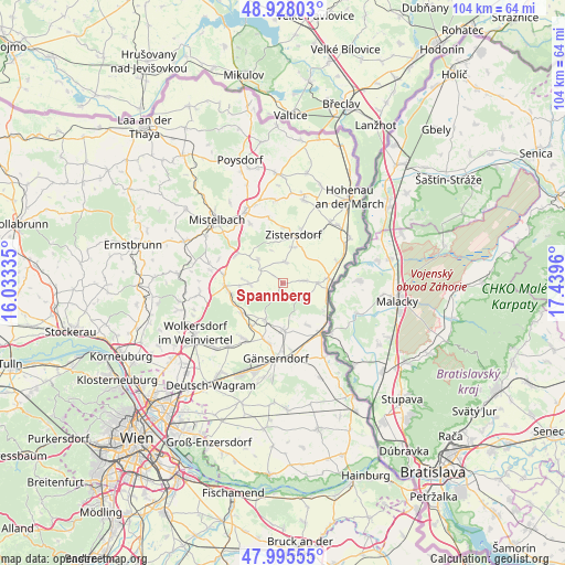
Spannberg GPS coordinates[2]
48° 27' 50.148" North, 16° 44' 11.292" East
| Map corner | latitude | longitude |
|---|---|---|
| Upper-left | 48.92803°, | 16.03335° |
| Center: | 48.46393°, | 16.73647° |
| Lower-right: | 47.99555°, | 17.4396° |
| Map W x H: | 103.7×103.7 km | = 64.4×64.4mi |
| max Lat: | 48.98333° ⇑6.9% North |
| Spannberg: | 48.46393° |
| min Lat: | ⇓93.1% South 46.48841° |
| min Long | Spannberg | max Long |
| 9.57802° | 16.73647° | 17.1° |
| W 97.7%⇐ | ⇒2.3% E |
Elevation
Elevation of Spannberg is 170 m = 558 ft, and this is 335.5 m = 1101 ft below average elevation for this country.
| Max E: |
2140 m = 7021 ft | 96.1% |
| Avg. | 505.5 m = 1658 ft | |
| Spannberg | 170 m = 558 ft | |
Min E: |
118 m = 387 ft | 3.9% |
See also: Austria elevation on elevation.city.
Geographical zone
Spannberg is located in North temperate zone (between Tropic of Cancer and the Arctic Circle). Distance of this North polar circle is 2012.5 km =1250.5 mi to North.| Distance of | km | miles | from Spannberg |
|---|---|---|---|
| North Pole | 4618.4 | 2869.7 | to North |
| Arctic Circle | 2012.5 | 1250.5 | to North |
| Tropic Cancer | 2782.8 | 1729.2 | to South |
| Equator | 5388.7 | 3348.4 | to South |


Nearby cities:
15 places around Spannberg: (largest is in red/bold)
• Bad Pirawarth
10.3 km =6.4 mi,  262°
262°
• Dürnkrut
8.5 km =5.3 mi,  83°
83°
• Ebenthal
4.8 km =3 mi,  134°
134°
• Groß-Inzersdorf
7.1 km =4.4 mi,  14°
14°
• Groß-Schweinbarth
9.5 km =5.9 mi,  234°
234°
• Hohenruppersdorf
6.2 km =3.9 mi,  270°
270°
• Loidesthal
2.4 km =1.5 mi,  24°
24°
• Matzen
7.6 km =4.7 mi,  200°
200°
• Obersulz
6.5 km =4 mi,  307°
307°
• Ollersdorf
8.5 km =5.3 mi,  146°
146°
• Prottes
8.6 km =5.3 mi,  178°
178°
• Raggendorf
9.7 km =6 mi,  216°
216°
• Schrick
9.7 km =6 mi,  294°
294°
• Waidendorf
6.4 km =4 mi,  88°
88°
• Zistersdorf
8.9 km =5.5 mi, 11°
Sources, notices
• [Note1] Compared only with cities in Austria existing in our database
• [Src1] Map data: © OpenStreetMap contributors (CC-BY-SA)
• [Src2] Other city data from geonames.org with taken over terms of usage.
• [Src3] Geographical zone / Annual Mean Temperature by Robert A. Rohde @ Wikipedia
