Zeillern geodata
Zeillern (Lower Austria) is a seat of a third-order administrative division; located in Austria in Europe/Vienna (GMT+2) time zone. With population of 1,865 people, there are 666 cities with bigger population in this country. Compared to other cities in Austria, 74.3% of cities are located further ↓South; 51.6% of cities are located further ←West and 76.7% of cities have higher elevation than Zeillern. Note1
Administrative division(s):
- Level 1: Lower Austria
- Level 2: Politischer Bezirk Amstetten
- Level 3: Zeillern


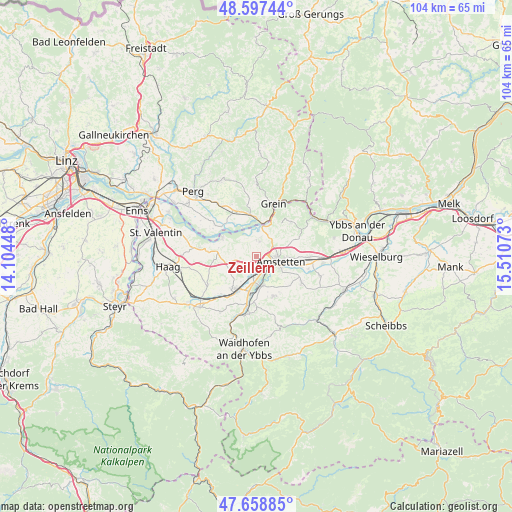
Zeillern GPS coordinates[2]
48° 7' 49.044" North, 14° 48' 27.36" East
| Map corner | latitude | longitude |
|---|---|---|
| Upper-left | 48.59744°, | 14.10448° |
| Center: | 48.13029°, | 14.8076° |
| Lower-right: | 47.65885°, | 15.51073° |
| Map W x H: | 104.4×104.4 km | = 64.9×64.9mi |
| max Lat: | 48.98333° ⇑25.7% North |
| Zeillern: | 48.13029° |
| min Lat: | ⇓74.3% South 46.48841° |
| min Long | Zeillern | max Long |
| 9.57802° | 14.8076° | 17.1° |
| W 51.6%⇐ | ⇒48.4% E |
Elevation
Elevation of Zeillern is 292 m = 958 ft, and this is 213.5 m = 700 ft below average elevation for this country.
| Max E: |
2140 m = 7021 ft | 76.7% |
| Avg. | 505.5 m = 1658 ft | |
| Zeillern | 292 m = 958 ft | |
Min E: |
118 m = 387 ft | 23.3% |
See also: Austria elevation on elevation.city.
Geographical zone
Zeillern is located in North temperate zone (between Tropic of Cancer and the Arctic Circle). Distance of this North polar circle is 2049.6 km =1273.6 mi to North.| Distance of | km | miles | from Zeillern |
|---|---|---|---|
| North Pole | 4655.5 | 2892.8 | to North |
| Arctic Circle | 2049.6 | 1273.6 | to North |
| Tropic Cancer | 2745.7 | 1706.1 | to South |
| Equator | 5351.6 | 3325.3 | to South |


Nearby cities:
15 places around Zeillern: (largest is in red/bold)
• Amstetten
4.9 km =3 mi,  99°
99°
• Ardagger Markt
4.1 km =2.5 mi,  9°
9°
• Ardagger Stift
2.9 km =1.8 mi,  41°
41°
• Aschbach Markt
7.6 km =4.7 mi,  211°
211°
• Greinsfurth
3.6 km =2.2 mi,  132°
132°
• Hausmening
6.6 km =4.1 mi,  175°
175°
• Kollmitzberg
5.1 km =3.2 mi, 37°
• Mauer bei Amstetten
3.8 km =2.4 mi,  187°
187°
• Neufurth
5.7 km =3.5 mi, 176°
• Oehling
3.4 km =2.1 mi, 189°
• Stephanshart
2.3 km =1.4 mi,  17°
17°
• Ulmerfeld
6 km =3.7 mi,  172°
172°
• Viehdorf
6.7 km =4.2 mi,  70°
70°
• Wallsee
7.9 km =4.9 mi,  300°
300°
• Winklarn
5.3 km =3.3 mi,  145°
145°
Sources, notices
• [Note1] Compared only with cities in Austria existing in our database
• [Src1] Map data: © OpenStreetMap contributors (CC-BY-SA)
• [Src2] Other city data from geonames.org with taken over terms of usage.
• [Src3] Geographical zone / Annual Mean Temperature by Robert A. Rohde @ Wikipedia
