Kollmitzberg geodata
Kollmitzberg (Lower Austria) is a populated place; located in Austria in Europe/Vienna (GMT+2) time zone. With population of 752 people, there are 1721 cities with bigger population in this country. Compared to other cities in Austria, 76.7% of cities are located further ↓South; 52.5% of cities are located further ←West and 76.1% of cities have higher elevation than Kollmitzberg. Note1
Administrative division(s):
- Level 1: Lower Austria
- Level 2: Politischer Bezirk Amstetten
- Level 3: Ardagger


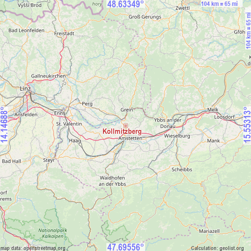
Kollmitzberg GPS coordinates[2]
48° 10' 0.012" North, 14° 51' 0" East
| Map corner | latitude | longitude |
|---|---|---|
| Upper-left | 48.63349°, | 14.14688° |
| Center: | 48.16667°, | 14.85° |
| Lower-right: | 47.69556°, | 15.55313° |
| Map W x H: | 104.3×104.3 km | = 64.8×64.8mi |
| max Lat: | 48.98333° ⇑23.3% North |
| Kollmitzberg: | 48.16667° |
| min Lat: | ⇓76.7% South 46.48841° |
| min Long | Kollmitzberg | max Long |
| 9.57802° | 14.85° | 17.1° |
| W 52.5%⇐ | ⇒47.5% E |
Elevation
Elevation of Kollmitzberg is 296 m = 971 ft, and this is 209.5 m = 687 ft below average elevation for this country.
| Max E: |
2140 m = 7021 ft | 76.1% |
| Avg. | 505.5 m = 1658 ft | |
| Kollmitzberg | 296 m = 971 ft | |
Min E: |
118 m = 387 ft | 23.9% |
See also: Austria elevation on elevation.city.
Geographical zone
Kollmitzberg is located in North temperate zone (between Tropic of Cancer and the Arctic Circle). Distance of this North polar circle is 2045.5 km =1271 mi to North.| Distance of | km | miles | from Kollmitzberg |
|---|---|---|---|
| North Pole | 4651.4 | 2890.2 | to North |
| Arctic Circle | 2045.5 | 1271 | to North |
| Tropic Cancer | 2749.7 | 1708.6 | to South |
| Equator | 5355.6 | 3327.8 | to South |


Nearby cities:
15 places around Kollmitzberg: (largest is in red/bold)
• Amstetten
5.1 km =3.2 mi,  161°
161°
• Ardagger Markt
2.5 km =1.6 mi,  270°
270°
• Ardagger Stift
2.2 km =1.4 mi,  213°
213°
• Grein
6.9 km =4.3 mi,  5°
5°
• Greinsfurth
6.5 km =4 mi,  184°
184°
• Mauer bei Amstetten
8.6 km =5.3 mi, 205°
• Neustadtl-Markt
4.8 km =3 mi,  52°
52°
• Oed
3.1 km =1.9 mi, 53°
• Oehling
8.3 km =5.2 mi, 206°
• Sankt Georgen am Ybbsfelde
8.8 km =5.5 mi,  118°
118°
• Saxen
6.4 km =4 mi,  316°
316°
• Stephanshart
3.1 km =1.9 mi,  233°
233°
• Viehdorf
3.6 km =2.2 mi, 119°
• Winklarn
8.4 km =5.2 mi, 180°
• Zeillern
5.1 km =3.2 mi,  217°
217°
Sources, notices
• [Note1] Compared only with cities in Austria existing in our database
• [Src1] Map data: © OpenStreetMap contributors (CC-BY-SA)
• [Src2] Other city data from geonames.org with taken over terms of usage.
• [Src3] Geographical zone / Annual Mean Temperature by Robert A. Rohde @ Wikipedia
