Wenns geodata
Wenns (Tyrol) is a seat of a third-order administrative division; located in Austria in Europe/Vienna (GMT+2) time zone. With population of 2,044 people, there are 599 cities with bigger population in this country. Compared to other cities in Austria, 75% of cities are located further ↑North; 94.7% of cities are located further →East and 92.9% of cities have lower elevation than Wenns. Note1


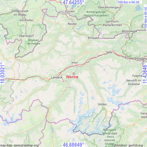
Wenns GPS coordinates[2]
47° 10' 0.012" North, 10° 43' 59.988" East
| Map corner | latitude | longitude |
|---|---|---|
| Upper-left | 47.64255°, | 10.03021° |
| Center: | 47.16667°, | 10.73333° |
| Lower-right: | 46.68649°, | 11.43646° |
| Map W x H: | 106.3×106.3 km | = 66.1×66.1mi |
| max Lat: | 48.98333° ⇑75% North |
| Wenns: | 47.16667° |
| min Lat: | ⇓25% South 46.48841° |
| min Long | Wenns | max Long |
| 9.57802° | 10.73333° | 17.1° |
| W 5.3%⇐ | ⇒94.7% E |
Elevation
Elevation of Wenns is 956 m = 3136 ft, and this is 450.5 m = 1478 ft above average elevation for this country.
| Max E: |
2140 m = 7021 ft | 7.1% |
| Wenns | 956 m 3136 ft | |
| Avg. | 505.5 m = 1658 ft | |
Min E: |
118 m = 387 ft | 92.9% |
See also: Austria elevation on elevation.city.
Geographical zone
Wenns is located in North temperate zone (between Tropic of Cancer and the Arctic Circle). Distance of this North polar circle is 2156.7 km =1340.1 mi to North.| Distance of | km | miles | from Wenns |
|---|---|---|---|
| North Pole | 4762.6 | 2959.3 | to North |
| Arctic Circle | 2156.7 | 1340.1 | to North |
| Tropic Cancer | 2638.5 | 1639.5 | to South |
| Equator | 5244.4 | 3258.7 | to South |


Nearby cities:
15 places around Wenns: (largest is in red/bold)
• Arzl im Pitztal
5 km =3.1 mi,  26°
26°
• Fliess
10.4 km =6.5 mi,  237°
237°
• Imst
8.7 km =5.4 mi,  3°
3°
• Imsterberg
5.1 km =3.2 mi,  326°
326°
• Jerzens
2 km =1.2 mi,  149°
149°
• Karres
6.7 km =4.2 mi, 34°
• Karrösten
7 km =4.3 mi,  20°
20°
• Kauns
10.3 km =6.4 mi,  197°
197°
• Mils bei Imst
6.2 km =3.9 mi,  314°
314°
• Prutz
10.5 km =6.5 mi,  208°
208°
• Roppen
8.4 km =5.2 mi,  48°
48°
• Sautens
10.7 km =6.6 mi,  69°
69°
• Schönwies
6.6 km =4.1 mi,  300°
300°
• Wald
4.5 km =2.8 mi, 34°
• Zams
10.9 km =6.8 mi,  265°
265°
Sources, notices
• [Note1] Compared only with cities in Austria existing in our database
• [Src1] Map data: © OpenStreetMap contributors (CC-BY-SA)
• [Src2] Other city data from geonames.org with taken over terms of usage.
• [Src3] Geographical zone / Annual Mean Temperature by Robert A. Rohde @ Wikipedia
