Imst geodata
Imst (Tyrol) is a seat of a third-order administrative division; located in Austria in Europe/Vienna (GMT+2) time zone. With population of 10,504 people, there are 74 cities with bigger population in this country. Compared to other cities in Austria, 69.5% of cities are located further ↑North; 94.7% of cities are located further →East and 86.7% of cities have lower elevation than Imst. Note1


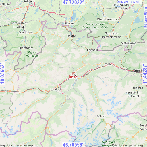
Imst GPS coordinates[2]
47° 14' 42.144" North, 10° 44' 23.064" East
| Map corner | latitude | longitude |
|---|---|---|
| Upper-left | 47.72022°, | 10.03662° |
| Center: | 47.24504°, | 10.73974° |
| Lower-right: | 46.76556°, | 11.44287° |
| Map W x H: | 106.1×106.1 km | = 65.9×65.9mi |
| max Lat: | 48.98333° ⇑69.5% North |
| Imst: | 47.24504° |
| min Lat: | ⇓30.5% South 46.48841° |
| min Long | Imst | max Long |
| 9.57802° | 10.73974° | 17.1° |
| W 5.3%⇐ | ⇒94.7% E |
Elevation
Elevation of Imst is 823 m = 2700 ft, and this is 317.5 m = 1042 ft above average elevation for this country.
| Max E: |
2140 m = 7021 ft | 13.3% |
| Imst | 823 m 2700 ft | |
| Avg. | 505.5 m = 1658 ft | |
Min E: |
118 m = 387 ft | 86.7% |
See also: Austria elevation on elevation.city.
Geographical zone
Imst is located in North temperate zone (between Tropic of Cancer and the Arctic Circle). Distance of this North polar circle is 2148 km =1334.7 mi to North.| Distance of | km | miles | from Imst |
|---|---|---|---|
| North Pole | 4753.9 | 2953.9 | to North |
| Arctic Circle | 2148 | 1334.7 | to North |
| Tropic Cancer | 2647.2 | 1644.9 | to South |
| Equator | 5253.2 | 3264.2 | to South |


Nearby cities:
15 places around Imst: (largest is in red/bold)
• Arzl im Pitztal
4.6 km =2.9 mi,  157°
157°
• Haiming
10.9 km =6.8 mi,  87°
87°
• Imsterberg
5.5 km =3.4 mi,  216°
216°
• Jerzens
10.4 km =6.5 mi,  177°
177°
• Karres
4.6 km =2.9 mi,  133°
133°
• Karrösten
2.9 km =1.8 mi,  138°
138°
• Mils bei Imst
6.5 km =4 mi,  228°
228°
• Nassereith
10.6 km =6.6 mi,  41°
41°
• Roppen
6.6 km =4.1 mi,  118°
118°
• Sautens
10.8 km =6.7 mi, 117°
• Schönwies
8.2 km =5.1 mi, 229°
• Tarrenz
3.1 km =1.9 mi, 40°
• Wald
5.4 km =3.4 mi, 157°
• Wenns
8.7 km =5.4 mi, 183°
• Ötztal-Bahnhof
8.4 km =5.2 mi,  98°
98°
Sources, notices
• [Note1] Compared only with cities in Austria existing in our database
• [Src1] Map data: © OpenStreetMap contributors (CC-BY-SA)
• [Src2] Other city data from geonames.org with taken over terms of usage.
• [Src3] Geographical zone / Annual Mean Temperature by Robert A. Rohde @ Wikipedia
