Wald geodata
Wald (Tyrol) is a populated place; located in Austria in Europe/Vienna (GMT+2) time zone. With population of 567 people, there are 2257 cities with bigger population in this country. Compared to other cities in Austria, 73% of cities are located further ↑North; 94.4% of cities are located further →East and 88.7% of cities have lower elevation than Wald. Note1
Administrative division(s):
- Level 1: Tyrol
- Level 2: Politischer Bezirk Imst
- Level 3: Arzl im Pitztal


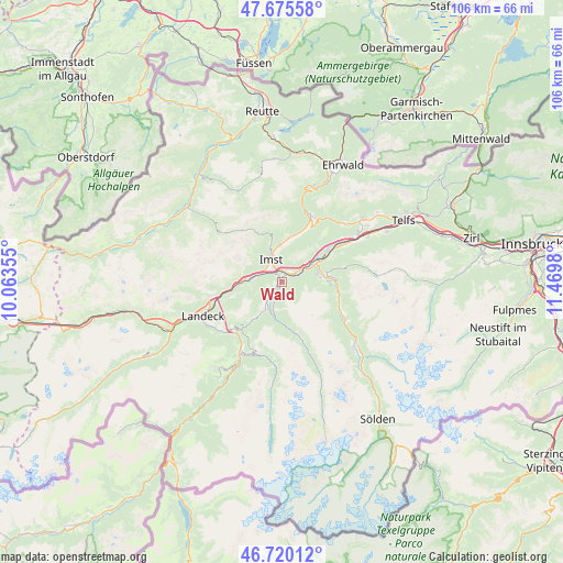
Wald GPS coordinates[2]
47° 12' 0" North, 10° 46' 0.012" East
| Map corner | latitude | longitude |
|---|---|---|
| Upper-left | 47.67558°, | 10.06355° |
| Center: | 47.2°, | 10.76667° |
| Lower-right: | 46.72012°, | 11.4698° |
| Map W x H: | 106.2×106.2 km | = 66×66mi |
| max Lat: | 48.98333° ⇑73% North |
| Wald: | 47.2° |
| min Lat: | ⇓27% South 46.48841° |
| min Long | Wald | max Long |
| 9.57802° | 10.76667° | 17.1° |
| W 5.6%⇐ | ⇒94.4% E |
Elevation
Elevation of Wald is 855 m = 2805 ft, and this is 349.5 m = 1147 ft above average elevation for this country.
| Max E: |
2140 m = 7021 ft | 11.3% |
| Wald | 855 m 2805 ft | |
| Avg. | 505.5 m = 1658 ft | |
Min E: |
118 m = 387 ft | 88.7% |
See also: Austria elevation on elevation.city.
Geographical zone
Wald is located in North temperate zone (between Tropic of Cancer and the Arctic Circle). Distance of this North polar circle is 2153 km =1337.8 mi to North.| Distance of | km | miles | from Wald |
|---|---|---|---|
| North Pole | 4758.9 | 2957 | to North |
| Arctic Circle | 2153 | 1337.8 | to North |
| Tropic Cancer | 2642.2 | 1641.8 | to South |
| Equator | 5248.1 | 3261 | to South |


Nearby cities:
15 places around Wald: (largest is in red/bold)
• Arzl im Pitztal
0.8 km =0.5 mi,  338°
338°
• Haiming
10.4 km =6.5 mi,  57°
57°
• Imst
5.4 km =3.4 mi, 337°
• Imsterberg
5.4 km =3.4 mi,  276°
276°
• Jerzens
5.6 km =3.5 mi,  195°
195°
• Karres
2.2 km =1.4 mi,  34°
34°
• Karrösten
2.8 km =1.7 mi,  358°
358°
• Mils bei Imst
7 km =4.3 mi, 275°
• Oetz
10.1 km =6.3 mi,  90°
90°
• Roppen
4.2 km =2.6 mi, 63°
• Sautens
7.6 km =4.7 mi, 90°
• Schönwies
8.3 km =5.2 mi,  267°
267°
• Tarrenz
7.4 km =4.6 mi,  0°
0°
• Wenns
4.5 km =2.8 mi,  214°
214°
• Ötztal-Bahnhof
7.3 km =4.5 mi, 59°
Sources, notices
• [Note1] Compared only with cities in Austria existing in our database
• [Src1] Map data: © OpenStreetMap contributors (CC-BY-SA)
• [Src2] Other city data from geonames.org with taken over terms of usage.
• [Src3] Geographical zone / Annual Mean Temperature by Robert A. Rohde @ Wikipedia
