Ungerdorf geodata
Ungerdorf (Styria) is a seat of a third-order administrative division; located in Austria in Europe/Vienna (GMT+2) time zone. With population of 900 people, there are 1428 cities with bigger population in this country. Compared to other cities in Austria, 80.3% of cities are located further ↑North; 70.9% of cities are located further ←West and 50.7% of cities have lower elevation than Ungerdorf. Note1


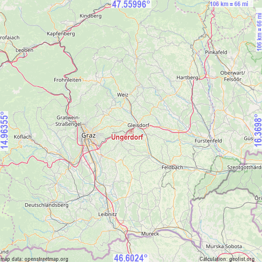
Ungerdorf GPS coordinates[2]
47° 4' 59.988" North, 15° 40' 0.012" East
| Map corner | latitude | longitude |
|---|---|---|
| Upper-left | 47.55996°, | 14.96355° |
| Center: | 47.08333°, | 15.66667° |
| Lower-right: | 46.6024°, | 16.3698° |
| Map W x H: | 106.5×106.5 km | = 66.2×66.2mi |
| max Lat: | 48.98333° ⇑80.3% North |
| Ungerdorf: | 47.08333° |
| min Lat: | ⇓19.7% South 46.48841° |
| min Long | Ungerdorf | max Long |
| 9.57802° | 15.66667° | 17.1° |
| W 70.9%⇐ | ⇒29.1% E |
Elevation
Elevation of Ungerdorf is 454 m = 1490 ft, and this is 51.5 m = 169 ft below average elevation for this country.
| Max E: |
2140 m = 7021 ft | 49.3% |
| Avg. | 505.5 m = 1658 ft | |
| Ungerdorf | 454 m = 1490 ft | |
Min E: |
118 m = 387 ft | 50.7% |
See also: Austria elevation on elevation.city.
Geographical zone
Ungerdorf is located in North temperate zone (between Tropic of Cancer and the Arctic Circle). Distance of this North polar circle is 2166 km =1345.9 mi to North.| Distance of | km | miles | from Ungerdorf |
|---|---|---|---|
| North Pole | 4771.9 | 2965.1 | to North |
| Arctic Circle | 2166 | 1345.9 | to North |
| Tropic Cancer | 2629.3 | 1633.8 | to South |
| Equator | 5235.2 | 3253 | to South |


Nearby cities:
15 places around Ungerdorf: (largest is in red/bold)
• Albersdorf
4.9 km =3 mi,  29°
29°
• Brodersdorf
5.3 km =3.3 mi,  314°
314°
• Entschendorf bei Gleisdorf
4.5 km =2.8 mi,  145°
145°
• Flöcking
0 km =0 mi,  0°
0°
• Fünfing bei Sankt Ruprecht an der Raab
5.7 km =3.5 mi,  347°
347°
• Gleisdorf
4.1 km =2.5 mi,  53°
53°
• Hofstätten an der Raab
5.4 km =3.4 mi,  110°
110°
• Labuch
1.9 km =1.2 mi,  180°
180°
• Langegg bei Graz
4.5 km =2.8 mi,  214°
214°
• Laßnitzthal
1.5 km =0.9 mi,  275°
275°
• Ludersdorf
2.8 km =1.7 mi,  37°
37°
• Nestelbach bei Graz
4.9 km =3 mi,  238°
238°
• Sulz bei Gleisdorf
5.4 km =3.4 mi, 110°
• Wilfersdorf bei Gleisdorf
1.9 km =1.2 mi, 0°
• Wünschendorf
4.2 km =2.6 mi,  63°
63°
Sources, notices
• [Note1] Compared only with cities in Austria existing in our database
• [Src1] Map data: © OpenStreetMap contributors (CC-BY-SA)
• [Src2] Other city data from geonames.org with taken over terms of usage.
• [Src3] Geographical zone / Annual Mean Temperature by Robert A. Rohde @ Wikipedia
