Hofstätten an der Raab geodata
Hofstätten an der Raab (Styria) is a seat of a third-order administrative division; located in Austria in Europe/Vienna (GMT+2) time zone. With population of 574 people, there are 2230 cities with bigger population in this country. Compared to other cities in Austria, 81.3% of cities are located further ↑North; 72.9% of cities are located further ←West and 63.9% of cities have higher elevation than Hofstätten an der Raab. Note1
Administrative division(s):
- Level 1: Styria
- Level 2: Politischer Bezirk Weiz
- Level 3: Hofstätten an der Raab


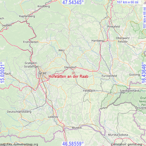
Hofstätten an der Raab GPS coordinates[2]
47° 4' 0.012" North, 15° 43' 59.988" East
| Map corner | latitude | longitude |
|---|---|---|
| Upper-left | 47.54345°, | 15.03021° |
| Center: | 47.06667°, | 15.73333° |
| Lower-right: | 46.58559°, | 16.43646° |
| Map W x H: | 106.5×106.5 km | = 66.2×66.2mi |
| max Lat: | 48.98333° ⇑81.3% North |
| Hofstätten an der Raab: | 47.06667° |
| min Lat: | ⇓18.7% South 46.48841° |
| min Long | Hofstätten an | max Long |
| 9.57802° | 15.73333° | 17.1° |
| W 72.9%⇐ | ⇒27.1% E |
Elevation
Elevation of Hofstätten an der Raab is 359 m = 1178 ft, and this is 146.5 m = 481 ft below average elevation for this country.
| Max E: |
2140 m = 7021 ft | 63.9% |
| Avg. | 505.5 m = 1658 ft | |
| Hofstätten an der Raab | 359 m = 1178 ft | |
Min E: |
118 m = 387 ft | 36.1% |
See also: Austria elevation on elevation.city.
Geographical zone
Hofstätten an der Raab is located in North temperate zone (between Tropic of Cancer and the Arctic Circle). Distance of this North polar circle is 2167.9 km =1347.1 mi to North.| Distance of | km | miles | from Hofstätten an der Raab |
|---|---|---|---|
| North Pole | 4773.7 | 2966.2 | to North |
| Arctic Circle | 2167.9 | 1347.1 | to North |
| Tropic Cancer | 2627.4 | 1632.6 | to South |
| Equator | 5233.3 | 3251.8 | to South |


Nearby cities:
15 places around Hofstätten an der Raab: (largest is in red/bold)
• Entschendorf bei Gleisdorf
3.1 km =1.9 mi,  233°
233°
• Flöcking
5.4 km =3.4 mi,  290°
290°
• Gleisdorf
4.7 km =2.9 mi,  337°
337°
• Labuch
5 km =3.1 mi,  270°
270°
• Ludersdorf
5.3 km =3.3 mi,  320°
320°
• Nitscha
5.7 km =3.5 mi,  12°
12°
• Pöllau bei Gleisdorf
5 km =3.1 mi,  90°
90°
• Sankt Marein bei Graz-Markt
6.7 km =4.2 mi,  211°
211°
• Sankt Marein bei Graz-Umgebung
5.6 km =3.5 mi, 207°
• Sankt Margarethen an der Raab
2.2 km =1.4 mi,  145°
145°
• Sulz bei Gleisdorf
0 km =0 mi,  0°
0°
• Takern Zwei
4.5 km =2.8 mi, 145°
• Ungerdorf
5.4 km =3.4 mi, 290°
• Wilfersdorf bei Gleisdorf
6.3 km =3.9 mi,  306°
306°
• Wünschendorf
3.9 km =2.4 mi, 341°
Sources, notices
• [Note1] Compared only with cities in Austria existing in our database
• [Src1] Map data: © OpenStreetMap contributors (CC-BY-SA)
• [Src2] Other city data from geonames.org with taken over terms of usage.
• [Src3] Geographical zone / Annual Mean Temperature by Robert A. Rohde @ Wikipedia
