Gleisdorf geodata
Gleisdorf (Styria) is a seat of a third-order administrative division; located in Austria in Europe/Vienna (GMT+2) time zone. With population of 6,418 people, there are 152 cities with bigger population in this country. Compared to other cities in Austria, 78.6% of cities are located further ↑North; 72.3% of cities are located further ←West and 63.2% of cities have higher elevation than Gleisdorf. Note1


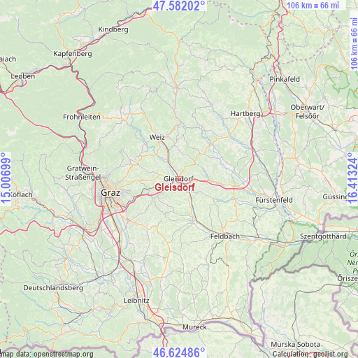
Gleisdorf GPS coordinates[2]
47° 6' 20.124" North, 15° 42' 36.396" East
| Map corner | latitude | longitude |
|---|---|---|
| Upper-left | 47.58202°, | 15.00699° |
| Center: | 47.10559°, | 15.71011° |
| Lower-right: | 46.62486°, | 16.41324° |
| Map W x H: | 106.4×106.4 km | = 66.1×66.1mi |
| max Lat: | 48.98333° ⇑78.6% North |
| Gleisdorf: | 47.10559° |
| min Lat: | ⇓21.4% South 46.48841° |
| min Long | Gleisdorf | max Long |
| 9.57802° | 15.71011° | 17.1° |
| W 72.3%⇐ | ⇒27.7% E |
Elevation
Elevation of Gleisdorf is 362 m = 1188 ft, and this is 143.5 m = 471 ft below average elevation for this country.
| Max E: |
2140 m = 7021 ft | 63.2% |
| Avg. | 505.5 m = 1658 ft | |
| Gleisdorf | 362 m = 1188 ft | |
Min E: |
118 m = 387 ft | 36.8% |
See also: Austria elevation on elevation.city.
Geographical zone
Gleisdorf is located in North temperate zone (between Tropic of Cancer and the Arctic Circle). Distance of this North polar circle is 2163.5 km =1344.3 mi to North.| Distance of | km | miles | from Gleisdorf |
|---|---|---|---|
| North Pole | 4769.4 | 2963.6 | to North |
| Arctic Circle | 2163.5 | 1344.3 | to North |
| Tropic Cancer | 2631.7 | 1635.3 | to South |
| Equator | 5237.7 | 3254.6 | to South |


Nearby cities:
15 places around Gleisdorf: (largest is in red/bold)
• Albersdorf
2 km =1.2 mi,  333°
333°
• Entschendorf bei Gleisdorf
6.2 km =3.9 mi,  187°
187°
• Flöcking
4.1 km =2.5 mi,  233°
233°
• Fünfing bei Sankt Ruprecht an der Raab
5.5 km =3.4 mi,  304°
304°
• Hofstätten an der Raab
4.7 km =2.9 mi,  157°
157°
• Labuch
5.4 km =3.4 mi,  217°
217°
• Laßnitzthal
5.3 km =3.3 mi,  244°
244°
• Ludersdorf
1.6 km =1 mi,  260°
260°
• Nitscha
3.3 km =2.1 mi,  67°
67°
• Prebensdorf
6.3 km =3.9 mi,  60°
60°
• Sankt Ruprecht an der Raab
6.4 km =4 mi, 325°
• Sulz bei Gleisdorf
4.7 km =2.9 mi, 157°
• Ungerdorf
4.1 km =2.5 mi, 233°
• Wilfersdorf bei Gleisdorf
3.3 km =2.1 mi, 259°
• Wünschendorf
0.8 km =0.5 mi,  141°
141°
Sources, notices
• [Note1] Compared only with cities in Austria existing in our database
• [Src1] Map data: © OpenStreetMap contributors (CC-BY-SA)
• [Src2] Other city data from geonames.org with taken over terms of usage.
• [Src3] Geographical zone / Annual Mean Temperature by Robert A. Rohde @ Wikipedia
