Turnau geodata
Turnau (Styria) is a seat of a third-order administrative division; located in Austria in Europe/Vienna (GMT+2) time zone. With population of 916 people, there are 1401 cities with bigger population in this country. Compared to other cities in Austria, 51.2% of cities are located further ↑North; 61.3% of cities are located further ←West and 81.9% of cities have lower elevation than Turnau. Note1
Administrative division(s):
- Level 1: Styria
- Level 2: Politischer Bezirk Bruck-Mürzzuschlag
- Level 3: Turnau


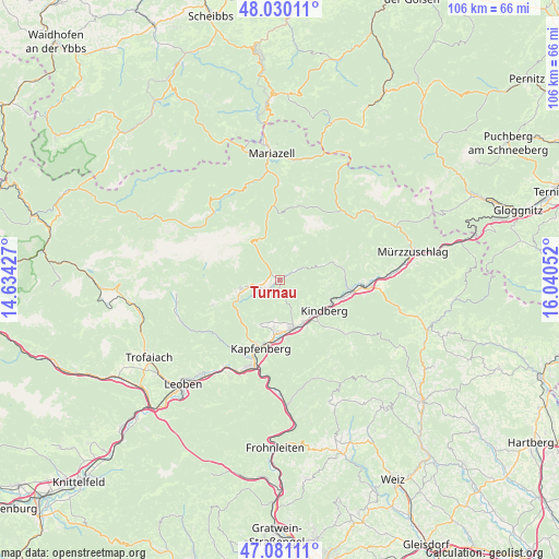
Turnau GPS coordinates[2]
47° 33' 27.936" North, 15° 20' 14.604" East
| Map corner | latitude | longitude |
|---|---|---|
| Upper-left | 48.03011°, | 14.63427° |
| Center: | 47.55776°, | 15.33739° |
| Lower-right: | 47.08111°, | 16.04052° |
| Map W x H: | 105.5×105.5 km | = 65.6×65.6mi |
| max Lat: | 48.98333° ⇑51.2% North |
| Turnau: | 47.55776° |
| min Lat: | ⇓48.8% South 46.48841° |
| min Long | Turnau | max Long |
| 9.57802° | 15.33739° | 17.1° |
| W 61.3%⇐ | ⇒38.7% E |
Elevation
Elevation of Turnau is 750 m = 2461 ft, and this is 244.5 m = 802 ft above average elevation for this country.
| Max E: |
2140 m = 7021 ft | 18.1% |
| Turnau | 750 m 2461 ft | |
| Avg. | 505.5 m = 1658 ft | |
Min E: |
118 m = 387 ft | 81.9% |
See also: Austria elevation on elevation.city.
Geographical zone
Turnau is located in North temperate zone (between Tropic of Cancer and the Arctic Circle). Distance of this North polar circle is 2113.2 km =1313.1 mi to North.| Distance of | km | miles | from Turnau |
|---|---|---|---|
| North Pole | 4719.1 | 2932.3 | to North |
| Arctic Circle | 2113.2 | 1313.1 | to North |
| Tropic Cancer | 2682 | 1666.5 | to South |
| Equator | 5287.9 | 3285.7 | to South |


Nearby cities:
15 places around Turnau: (largest is in red/bold)
• Aflenz Kurort
7.6 km =4.7 mi,  256°
256°
• Allerheiligen im Mürztal
11.2 km =7 mi,  155°
155°
• Deuchendorf
10.3 km =6.4 mi,  186°
186°
• Fölz
8.3 km =5.2 mi,  250°
250°
• Gassing
9.4 km =5.8 mi,  177°
177°
• Grossveitsch
10.6 km =6.6 mi,  71°
71°
• Göritz
8 km =5 mi, 182°
• Kindberg
10.6 km =6.6 mi,  127°
127°
• Mürzhofen
9 km =5.6 mi, 157°
• Palbersdorf
8.3 km =5.2 mi, 250°
• Parschlug
9.4 km =5.8 mi,  204°
204°
• Sankt Lorenzen im Mürztal
8.6 km =5.3 mi,  165°
165°
• Sankt Marein im Mürztal
10.4 km =6.5 mi, 167°
• Schaldorf
10.2 km =6.3 mi, 164°
• Thörl
9.6 km =6 mi,  243°
243°
Sources, notices
• [Note1] Compared only with cities in Austria existing in our database
• [Src1] Map data: © OpenStreetMap contributors (CC-BY-SA)
• [Src2] Other city data from geonames.org with taken over terms of usage.
• [Src3] Geographical zone / Annual Mean Temperature by Robert A. Rohde @ Wikipedia
