Traboch geodata
Traboch (Styria) is a seat of a third-order administrative division; located in Austria in Europe/Vienna (GMT+2) time zone. With population of 478 people, there are 2527 cities with bigger population in this country. Compared to other cities in Austria, 61.2% of cities are located further ↑North; 54.2% of cities are located further ←West and 72.5% of cities have lower elevation than Traboch. Note1


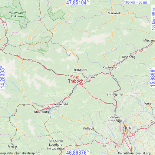
Traboch GPS coordinates[2]
47° 22' 37.38" North, 14° 59' 11.292" East
| Map corner | latitude | longitude |
|---|---|---|
| Upper-left | 47.85104°, | 14.28335° |
| Center: | 47.37705°, | 14.98647° |
| Lower-right: | 46.89876°, | 15.6896° |
| Map W x H: | 105.9×105.9 km | = 65.8×65.8mi |
| max Lat: | 48.98333° ⇑61.2% North |
| Traboch: | 47.37705° |
| min Lat: | ⇓38.8% South 46.48841° |
| min Long | Traboch | max Long |
| 9.57802° | 14.98647° | 17.1° |
| W 54.2%⇐ | ⇒45.8% E |
Elevation
Elevation of Traboch is 619 m = 2031 ft, and this is 113.5 m = 372 ft above average elevation for this country.
| Max E: |
2140 m = 7021 ft | 27.5% |
| Traboch | 619 m 2031 ft | |
| Avg. | 505.5 m = 1658 ft | |
Min E: |
118 m = 387 ft | 72.5% |
See also: Austria elevation on elevation.city.
Geographical zone
Traboch is located in North temperate zone (between Tropic of Cancer and the Arctic Circle). Distance of this North polar circle is 2133.3 km =1325.6 mi to North.| Distance of | km | miles | from Traboch |
|---|---|---|---|
| North Pole | 4739.2 | 2944.8 | to North |
| Arctic Circle | 2133.3 | 1325.6 | to North |
| Tropic Cancer | 2661.9 | 1654 | to South |
| Equator | 5267.8 | 3273.3 | to South |


Nearby cities:
15 places around Traboch: (largest is in red/bold)
• Donawitz
6.1 km =3.8 mi,  100°
100°
• Göss
8.8 km =5.5 mi, 103°
• Hessenberg
3.2 km =2 mi,  44°
44°
• Hinterberg
6.5 km =4 mi,  106°
106°
• Judendorf
8.9 km =5.5 mi,  73°
73°
• Kammern im Liesingtal
6.4 km =4 mi,  285°
285°
• Laintal
6.7 km =4.2 mi, 36°
• Leitendorf
7.4 km =4.6 mi, 98°
• Leoben
7.9 km =4.9 mi,  90°
90°
• Liesingtal
4 km =2.5 mi,  149°
149°
• Sankt Michael in Obersteiermark
4.9 km =3 mi, 151°
• Sankt Peter-Freienstein
2.4 km =1.5 mi, 72°
• Sankt Stefan ob Leoben
6.7 km =4.2 mi,  185°
185°
• Timmersdorf
0.8 km =0.5 mi,  276°
276°
• Trofaiach
5.6 km =3.5 mi,  15°
15°
Sources, notices
• [Note1] Compared only with cities in Austria existing in our database
• [Src1] Map data: © OpenStreetMap contributors (CC-BY-SA)
• [Src2] Other city data from geonames.org with taken over terms of usage.
• [Src3] Geographical zone / Annual Mean Temperature by Robert A. Rohde @ Wikipedia
