Leitendorf geodata
Leitendorf (Styria) is a section of populated place; located in Austria in Europe/Vienna (GMT+2) time zone. With population of 2,568 people, there are 461 cities with bigger population in this country. Compared to other cities in Austria, 61.9% of cities are located further ↑North; 55.5% of cities are located further ←West and 69.1% of cities have lower elevation than Leitendorf. Note1


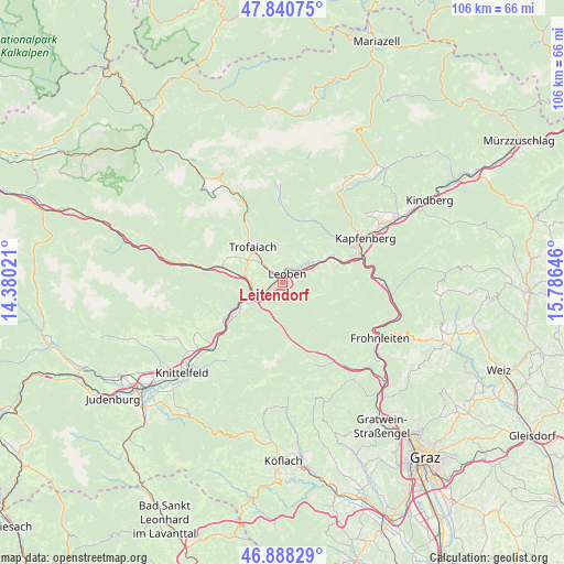
Leitendorf GPS coordinates[2]
47° 22' 0.012" North, 15° 4' 59.988" East
| Map corner | latitude | longitude |
|---|---|---|
| Upper-left | 47.84075°, | 14.38021° |
| Center: | 47.36667°, | 15.08333° |
| Lower-right: | 46.88829°, | 15.78646° |
| Map W x H: | 105.9×105.9 km | = 65.8×65.8mi |
| max Lat: | 48.98333° ⇑61.9% North |
| Leitendorf: | 47.36667° |
| min Lat: | ⇓38.1% South 46.48841° |
| min Long | Leitendorf | max Long |
| 9.57802° | 15.08333° | 17.1° |
| W 55.5%⇐ | ⇒44.5% E |
Elevation
Elevation of Leitendorf is 581 m = 1906 ft, and this is 75.5 m = 248 ft above average elevation for this country.
| Max E: |
2140 m = 7021 ft | 30.9% |
| Leitendorf | 581 m 1906 ft | |
| Avg. | 505.5 m = 1658 ft | |
Min E: |
118 m = 387 ft | 69.1% |
See also: Austria elevation on elevation.city.
Geographical zone
Leitendorf is located in North temperate zone (between Tropic of Cancer and the Arctic Circle). Distance of this North polar circle is 2134.5 km =1326.3 mi to North.| Distance of | km | miles | from Leitendorf |
|---|---|---|---|
| North Pole | 4740.4 | 2945.5 | to North |
| Arctic Circle | 2134.5 | 1326.3 | to North |
| Tropic Cancer | 2660.8 | 1653.3 | to South |
| Equator | 5266.7 | 3272.6 | to South |


Nearby cities:
15 places around Leitendorf: (largest is in red/bold)
• Donawitz
1.3 km =0.8 mi,  270°
270°
• Göss
1.5 km =0.9 mi,  124°
124°
• Hessenberg
6.1 km =3.8 mi,  304°
304°
• Hinterberg
1.2 km =0.7 mi,  237°
237°
• Judendorf
3.9 km =2.4 mi,  18°
18°
• Laintal
7.4 km =4.6 mi,  333°
333°
• Leoben
1.3 km =0.8 mi,  29°
29°
• Liesingtal
5.7 km =3.5 mi,  246°
246°
• Niklasdorf
5.4 km =3.4 mi,  69°
69°
• Proleb
5.3 km =3.3 mi,  45°
45°
• Sankt Michael in Obersteiermark
5.9 km =3.7 mi, 237°
• Sankt Peter-Freienstein
5.4 km =3.4 mi,  290°
290°
• Timmersdorf
8.2 km =5.1 mi,  278°
278°
• Traboch
7.4 km =4.6 mi, 278°
• Trofaiach
8.7 km =5.4 mi,  318°
318°
Sources, notices
• [Note1] Compared only with cities in Austria existing in our database
• [Src1] Map data: © OpenStreetMap contributors (CC-BY-SA)
• [Src2] Other city data from geonames.org with taken over terms of usage.
• [Src3] Geographical zone / Annual Mean Temperature by Robert A. Rohde @ Wikipedia
