Strobl geodata
Strobl (Salzburg) is a seat of a third-order administrative division; located in Austria in Europe/Vienna (GMT+2) time zone. With population of 1,393 people, there are 901 cities with bigger population in this country. Compared to other cities in Austria, 54.1% of cities are located further ↓South; 75.2% of cities are located further →East and 64.2% of cities have lower elevation than Strobl. Note1
Administrative division(s):
- Level 1: Salzburg
- Level 2: Politischer Bezirk Salzburg-Umgebung
- Level 3: Strobl


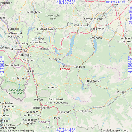
Strobl GPS coordinates[2]
47° 43' 0.012" North, 13° 28' 59.988" East
| Map corner | latitude | longitude |
|---|---|---|
| Upper-left | 48.18758°, | 12.78021° |
| Center: | 47.71667°, | 13.48333° |
| Lower-right: | 47.24146°, | 14.18646° |
| Map W x H: | 105.2×105.2 km | = 65.4×65.4mi |
| max Lat: | 48.98333° ⇑45.9% North |
| Strobl: | 47.71667° |
| min Lat: | ⇓54.1% South 46.48841° |
| min Long | Strobl | max Long |
| 9.57802° | 13.48333° | 17.1° |
| W 24.8%⇐ | ⇒75.2% E |
Elevation
Elevation of Strobl is 546 m = 1791 ft, and this is 40.5 m = 133 ft above average elevation for this country.
| Max E: |
2140 m = 7021 ft | 35.8% |
| Strobl | 546 m 1791 ft | |
| Avg. | 505.5 m = 1658 ft | |
Min E: |
118 m = 387 ft | 64.2% |
See also: Austria elevation on elevation.city.
Geographical zone
Strobl is located in North temperate zone (between Tropic of Cancer and the Arctic Circle). Distance of this North polar circle is 2095.6 km =1302.1 mi to North.| Distance of | km | miles | from Strobl |
|---|---|---|---|
| North Pole | 4701.5 | 2921.4 | to North |
| Arctic Circle | 2095.6 | 1302.1 | to North |
| Tropic Cancer | 2699.7 | 1677.5 | to South |
| Equator | 5305.6 | 3296.7 | to South |


Nearby cities:
15 places around Strobl: (largest is in red/bold)
• Ahorn
9 km =5.6 mi,  93°
93°
• Aigen
4.2 km =2.6 mi,  116°
116°
• Bad Ischl
10.2 km =6.3 mi, 93°
• Gschwandt
6.6 km =4.1 mi,  292°
292°
• Gschwendt
3.7 km =2.3 mi,  270°
270°
• Haiden
6.4 km =4 mi, 88°
• Jainzen
10 km =6.2 mi, 90°
• Kaltenbach
9.5 km =5.9 mi,  97°
97°
• Kreutern
8.1 km =5 mi, 86°
• Markt
3.7 km =2.3 mi,  312°
312°
• Sankt Gilgen
10.3 km =6.4 mi,  302°
302°
• Sankt Wolfgang im Salzkammergut
3.7 km =2.3 mi, 312°
• Sulzbach
10.5 km =6.5 mi, 102°
• Unterach (Attersee)
9.8 km =6.1 mi,  1°
1°
• Weissenbach
2.2 km =1.4 mi,  146°
146°
Sources, notices
• [Note1] Compared only with cities in Austria existing in our database
• [Src1] Map data: © OpenStreetMap contributors (CC-BY-SA)
• [Src2] Other city data from geonames.org with taken over terms of usage.
• [Src3] Geographical zone / Annual Mean Temperature by Robert A. Rohde @ Wikipedia
