Gschwandt geodata
Gschwandt (Salzburg) is a populated place; located in Austria in Europe/Vienna (GMT+2) time zone. With population of 909 people, there are 1415 cities with bigger population in this country. Compared to other cities in Austria, 55.2% of cities are located further ↓South; 76.5% of cities are located further →East and 63.2% of cities have lower elevation than Gschwandt. Note1
Administrative division(s):
- Level 1: Salzburg
- Level 2: Politischer Bezirk Salzburg-Umgebung
- Level 3: Sankt Gilgen


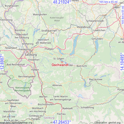
Gschwandt GPS coordinates[2]
47° 44' 22.308" North, 13° 24' 6.552" East
| Map corner | latitude | longitude |
|---|---|---|
| Upper-left | 48.21024°, | 12.6987° |
| Center: | 47.73953°, | 13.40182° |
| Lower-right: | 47.26453°, | 14.10495° |
| Map W x H: | 105.2×105.2 km | = 65.4×65.4mi |
| max Lat: | 48.98333° ⇑44.8% North |
| Gschwandt: | 47.73953° |
| min Lat: | ⇓55.2% South 46.48841° |
| min Long | Gschwandt | max Long |
| 9.57802° | 13.40182° | 17.1° |
| W 23.5%⇐ | ⇒76.5% E |
Elevation
Elevation of Gschwandt is 540 m = 1772 ft, and this is 34.5 m = 113 ft above average elevation for this country.
| Max E: |
2140 m = 7021 ft | 36.8% |
| Gschwandt | 540 m 1772 ft | |
| Avg. | 505.5 m = 1658 ft | |
Min E: |
118 m = 387 ft | 63.2% |
See also: Austria elevation on elevation.city.
Geographical zone
Gschwandt is located in North temperate zone (between Tropic of Cancer and the Arctic Circle). Distance of this North polar circle is 2093 km =1300.5 mi to North.| Distance of | km | miles | from Gschwandt |
|---|---|---|---|
| North Pole | 4698.9 | 2919.8 | to North |
| Arctic Circle | 2093 | 1300.5 | to North |
| Tropic Cancer | 2702.2 | 1679.1 | to South |
| Equator | 5308.1 | 3298.3 | to South |


Nearby cities:
15 places around Gschwandt: (largest is in red/bold)
• Aigen
10.8 km =6.7 mi,  114°
114°
• Fuschl am See
10.2 km =6.3 mi,  311°
311°
• Gschwendt
3.5 km =2.2 mi,  137°
137°
• Haiden
12.7 km =7.9 mi,  100°
100°
• Hintersee
9.9 km =6.2 mi,  243°
243°
• Innerschwand
10.4 km =6.5 mi,  359°
359°
• Markt
3.4 km =2.1 mi,  90°
90°
• Pöllach
6.2 km =3.9 mi,  321°
321°
• Sankt Gilgen
4 km =2.5 mi, 318°
• Sankt Lorenz
11.1 km =6.9 mi,  338°
338°
• Sankt Wolfgang im Salzkammergut
3.4 km =2.1 mi, 90°
• Strobl
6.6 km =4.1 mi, 112°
• Unterach (Attersee)
9.7 km =6 mi,  41°
41°
• Vordersee
11.4 km =7.1 mi,  275°
275°
• Weissenbach
8.6 km =5.3 mi,  120°
120°
Sources, notices
• [Note1] Compared only with cities in Austria existing in our database
• [Src1] Map data: © OpenStreetMap contributors (CC-BY-SA)
• [Src2] Other city data from geonames.org with taken over terms of usage.
• [Src3] Geographical zone / Annual Mean Temperature by Robert A. Rohde @ Wikipedia
