Sistrans geodata
Sistrans (Tyrol) is a seat of a third-order administrative division; located in Austria in Europe/Vienna (GMT+2) time zone. With population of 2,255 people, there are 539 cities with bigger population in this country. Compared to other cities in Austria, 70.3% of cities are located further ↑North; 91.9% of cities are located further →East and 94.2% of cities have lower elevation than Sistrans. Note1
Administrative division(s):
- Level 1: Tyrol
- Level 2: Politischer Bezirk Innsbruck Land
- Level 3: Sistrans


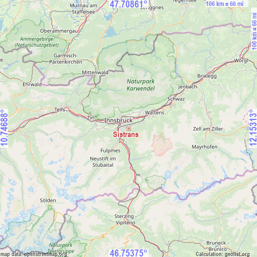
Sistrans GPS coordinates[2]
47° 13' 59.988" North, 11° 27' 0" East
| Map corner | latitude | longitude |
|---|---|---|
| Upper-left | 47.70861°, | 10.74688° |
| Center: | 47.23333°, | 11.45° |
| Lower-right: | 46.75375°, | 12.15313° |
| Map W x H: | 106.2×106.2 km | = 66×66mi |
| max Lat: | 48.98333° ⇑70.3% North |
| Sistrans: | 47.23333° |
| min Lat: | ⇓29.7% South 46.48841° |
| min Long | Sistrans | max Long |
| 9.57802° | 11.45° | 17.1° |
| W 8.1%⇐ | ⇒91.9% E |
Elevation
Elevation of Sistrans is 988 m = 3241 ft, and this is 482.5 m = 1583 ft above average elevation for this country.
| Max E: |
2140 m = 7021 ft | 5.8% |
| Sistrans | 988 m 3241 ft | |
| Avg. | 505.5 m = 1658 ft | |
Min E: |
118 m = 387 ft | 94.2% |
See also: Austria elevation on elevation.city.
Geographical zone
Sistrans is located in North temperate zone (between Tropic of Cancer and the Arctic Circle). Distance of this North polar circle is 2149.3 km =1335.5 mi to North.| Distance of | km | miles | from Sistrans |
|---|---|---|---|
| North Pole | 4755.2 | 2954.7 | to North |
| Arctic Circle | 2149.3 | 1335.5 | to North |
| Tropic Cancer | 2645.9 | 1644.1 | to South |
| Equator | 5251.9 | 3263.4 | to South |


Nearby cities:
15 places around Sistrans: (largest is in red/bold)
• Aldrans
1.9 km =1.2 mi,  0°
0°
• Ampass
3.4 km =2.1 mi,  15°
15°
• Amras
3.1 km =1.9 mi,  306°
306°
• Arzl
5.7 km =3.5 mi,  347°
347°
• Igls
3 km =1.9 mi,  265°
265°
• Innsbruck
5.3 km =3.3 mi, 307°
• Lans
1.5 km =0.9 mi,  291°
291°
• Mutters
5 km =3.1 mi, 270°
• Natters
5.8 km =3.6 mi, 270°
• Patsch
4.1 km =2.5 mi,  220°
220°
• Pradl
4.4 km =2.7 mi,  323°
323°
• Rinn
4.2 km =2.6 mi,  63°
63°
• Rum
5.6 km =3.5 mi, 0°
• Vill
3.8 km =2.4 mi, 270°
• Wilten
5.4 km =3.4 mi,  300°
300°
Sources, notices
• [Note1] Compared only with cities in Austria existing in our database
• [Src1] Map data: © OpenStreetMap contributors (CC-BY-SA)
• [Src2] Other city data from geonames.org with taken over terms of usage.
• [Src3] Geographical zone / Annual Mean Temperature by Robert A. Rohde @ Wikipedia
