Arzl geodata
Arzl (Tyrol) is a section of populated place; located in Austria in Europe/Vienna (GMT+2) time zone. With population of 11,082 people, there are 72 cities with bigger population in this country. Compared to other cities in Austria, 67.2% of cities are located further ↑North; 91.9% of cities are located further →East and 74.1% of cities have lower elevation than Arzl. Note1


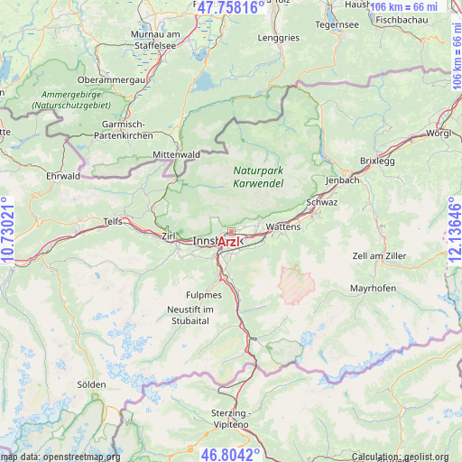
Arzl GPS coordinates[2]
47° 16' 59.988" North, 11° 25' 59.988" East
| Map corner | latitude | longitude |
|---|---|---|
| Upper-left | 47.75816°, | 10.73021° |
| Center: | 47.28333°, | 11.43333° |
| Lower-right: | 46.8042°, | 12.13646° |
| Map W x H: | 106.1×106.1 km | = 65.9×65.9mi |
| max Lat: | 48.98333° ⇑67.2% North |
| Arzl: | 47.28333° |
| min Lat: | ⇓32.8% South 46.48841° |
| min Long | Arzl | max Long |
| 9.57802° | 11.43333° | 17.1° |
| W 8.1%⇐ | ⇒91.9% E |
Elevation
Elevation of Arzl is 638 m = 2093 ft, and this is 132.5 m = 435 ft above average elevation for this country.
| Max E: |
2140 m = 7021 ft | 25.9% |
| Arzl | 638 m 2093 ft | |
| Avg. | 505.5 m = 1658 ft | |
Min E: |
118 m = 387 ft | 74.1% |
See also: Austria elevation on elevation.city.
Geographical zone
Arzl is located in North temperate zone (between Tropic of Cancer and the Arctic Circle). Distance of this North polar circle is 2143.8 km =1332.1 mi to North.| Distance of | km | miles | from Arzl |
|---|---|---|---|
| North Pole | 4749.6 | 2951.3 | to North |
| Arctic Circle | 2143.8 | 1332.1 | to North |
| Tropic Cancer | 2651.5 | 1647.6 | to South |
| Equator | 5257.4 | 3266.8 | to South |


Nearby cities:
15 places around Arzl: (largest is in red/bold)
• Absam
5.6 km =3.5 mi,  75°
75°
• Aldrans
3.9 km =2.4 mi,  161°
161°
• Ampass
3.2 km =2 mi,  136°
136°
• Amras
3.9 km =2.4 mi,  198°
198°
• Heiligkreuz
4.5 km =2.8 mi,  86°
86°
• Hötting
5.2 km =3.2 mi,  250°
250°
• Igls
6 km =3.7 mi, 196°
• Innsbruck
3.7 km =2.3 mi,  231°
231°
• Lans
5 km =3.1 mi,  181°
181°
• Mühlau
2.5 km =1.6 mi,  270°
270°
• Pradl
2.4 km =1.5 mi,  214°
214°
• Rum
1.3 km =0.8 mi, 90°
• Sistrans
5.7 km =3.5 mi,  167°
167°
• Thaur
3.4 km =2.1 mi,  68°
68°
• Wilten
4.4 km =2.7 mi, 230°
Sources, notices
• [Note1] Compared only with cities in Austria existing in our database
• [Src1] Map data: © OpenStreetMap contributors (CC-BY-SA)
• [Src2] Other city data from geonames.org with taken over terms of usage.
• [Src3] Geographical zone / Annual Mean Temperature by Robert A. Rohde @ Wikipedia
