Rinn geodata
Rinn (Tyrol) is a seat of a third-order administrative division; located in Austria in Europe/Vienna (GMT+2) time zone. With population of 1,877 people, there are 662 cities with bigger population in this country. Compared to other cities in Austria, 69.4% of cities are located further ↑North; 91.3% of cities are located further →East and 91.3% of cities have lower elevation than Rinn. Note1


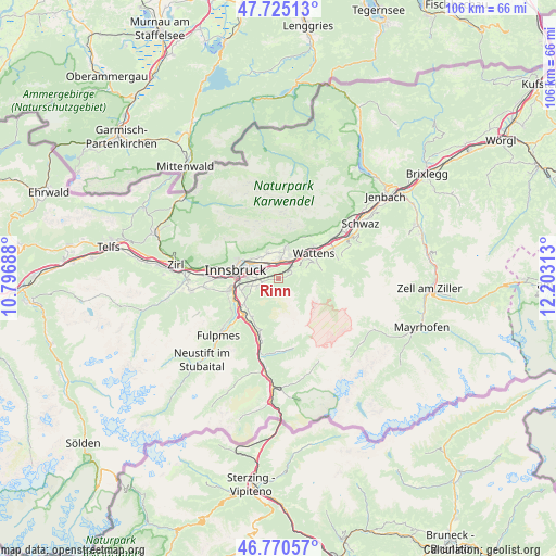
Rinn GPS coordinates[2]
47° 15' 0" North, 11° 30' 0" East
| Map corner | latitude | longitude |
|---|---|---|
| Upper-left | 47.72513°, | 10.79688° |
| Center: | 47.25°, | 11.5° |
| Lower-right: | 46.77057°, | 12.20313° |
| Map W x H: | 106.1×106.1 km | = 65.9×65.9mi |
| max Lat: | 48.98333° ⇑69.4% North |
| Rinn: | 47.25° |
| min Lat: | ⇓30.6% South 46.48841° |
| min Long | Rinn | max Long |
| 9.57802° | 11.5° | 17.1° |
| W 8.7%⇐ | ⇒91.3% E |
Elevation
Elevation of Rinn is 907 m = 2976 ft, and this is 401.5 m = 1317 ft above average elevation for this country.
| Max E: |
2140 m = 7021 ft | 8.7% |
| Rinn | 907 m 2976 ft | |
| Avg. | 505.5 m = 1658 ft | |
Min E: |
118 m = 387 ft | 91.3% |
See also: Austria elevation on elevation.city.
Geographical zone
Rinn is located in North temperate zone (between Tropic of Cancer and the Arctic Circle). Distance of this North polar circle is 2147.5 km =1334.4 mi to North.| Distance of | km | miles | from Rinn |
|---|---|---|---|
| North Pole | 4753.4 | 2953.6 | to North |
| Arctic Circle | 2147.5 | 1334.4 | to North |
| Tropic Cancer | 2647.8 | 1645.3 | to South |
| Equator | 5253.7 | 3264.5 | to South |


Nearby cities:
15 places around Rinn: (largest is in red/bold)
• Absam
5.1 km =3.2 mi,  5°
5°
• Aldrans
3.8 km =2.4 mi,  270°
270°
• Ampass
3.2 km =2 mi,  296°
296°
• Amras
6.3 km =3.9 mi, 270°
• Arzl
6.2 km =3.9 mi,  306°
306°
• Hall in Tirol
3.9 km =2.4 mi,  18°
18°
• Heiligkreuz
4 km =2.5 mi,  352°
352°
• Lans
5.3 km =3.3 mi,  255°
255°
• Mils bei Solbad Hall
4.5 km =2.8 mi,  34°
34°
• Pradl
6.6 km =4.1 mi,  284°
284°
• Rum
5.3 km =3.3 mi, 314°
• Sistrans
4.2 km =2.6 mi,  243°
243°
• Thaur
5.3 km =3.3 mi,  339°
339°
• Tulfes
2.7 km =1.7 mi,  70°
70°
• Volders
6.2 km =3.9 mi,  53°
53°
Sources, notices
• [Note1] Compared only with cities in Austria existing in our database
• [Src1] Map data: © OpenStreetMap contributors (CC-BY-SA)
• [Src2] Other city data from geonames.org with taken over terms of usage.
• [Src3] Geographical zone / Annual Mean Temperature by Robert A. Rohde @ Wikipedia
