Schlüsslberg geodata
Schlüsslberg (Upper Austria) is a seat of a third-order administrative division; located in Austria in Europe/Vienna (GMT+1) time zone. With population of 898 people, there are 1435 cities with bigger population in this country. Compared to other cities in Austria, 80.7% of cities are located further ↓South; 67.4% of cities are located further →East and 71.1% of cities have higher elevation than Schlüsslberg. Note1
Administrative division(s):
- Level 1: Upper Austria
- Level 2: Politischer Bezirk Grieskirchen
- Level 3: Schlüsslberg


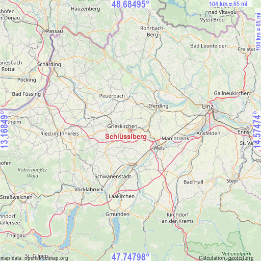
Schlüsslberg GPS coordinates[2]
48° 13' 6.996" North, 13° 52' 17.796" East
| Map corner | latitude | longitude |
|---|---|---|
| Upper-left | 48.68495°, | 13.16849° |
| Center: | 48.21861°, | 13.87161° |
| Lower-right: | 47.74798°, | 14.57474° |
| Map W x H: | 104.2×104.2 km | = 64.7×64.7mi |
| max Lat: | 48.98333° ⇑19.3% North |
| Schlüsslberg: | 48.21861° |
| min Lat: | ⇓80.7% South 46.48841° |
| min Long | Schlüsslberg | max Long |
| 9.57802° | 13.87161° | 17.1° |
| W 32.6%⇐ | ⇒67.4% E |
Elevation
Elevation of Schlüsslberg is 322 m = 1056 ft, and this is 183.5 m = 602 ft below average elevation for this country.
| Max E: |
2140 m = 7021 ft | 71.1% |
| Avg. | 505.5 m = 1658 ft | |
| Schlüsslberg | 322 m = 1056 ft | |
Min E: |
118 m = 387 ft | 28.9% |
See also: Austria elevation on elevation.city.
Geographical zone
Schlüsslberg is located in North temperate zone (between Tropic of Cancer and the Arctic Circle). Distance of this North polar circle is 2039.8 km =1267.5 mi to North.| Distance of | km | miles | from Schlüsslberg |
|---|---|---|---|
| North Pole | 4645.7 | 2886.7 | to North |
| Arctic Circle | 2039.8 | 1267.5 | to North |
| Tropic Cancer | 2755.5 | 1712.2 | to South |
| Equator | 5361.4 | 3331.4 | to South |


Nearby cities:
15 places around Schlüsslberg: (largest is in red/bold)
• Bad Schallerbach
3.7 km =2.3 mi,  70°
70°
• Gallspach
4.7 km =2.9 mi,  258°
258°
• Grieskirchen
3.3 km =2.1 mi,  299°
299°
• Kematen am Innbach
4.8 km =3 mi,  191°
191°
• Krenglbach
6.4 km =4 mi,  103°
103°
• Meggenhofen
7.1 km =4.4 mi,  232°
232°
• Michaelnbach
8.3 km =5.2 mi,  338°
338°
• Offenhausen
8.1 km =5 mi,  200°
200°
• Pennewang
9.6 km =6 mi, 189°
• Pichl bei Wels
4.2 km =2.6 mi,  151°
151°
• Sankt Marienkirchen an der Polsenz
6.8 km =4.2 mi,  40°
40°
• Taufkirchen an der Trattnach
9.7 km =6 mi,  289°
289°
• Tolleterau
6.7 km =4.2 mi,  284°
284°
• Unterfreundorf
6.9 km =4.3 mi,  48°
48°
• Wallern an der Trattnach
5.8 km =3.6 mi, 73°
Sources, notices
• [Note1] Compared only with cities in Austria existing in our database
• [Src1] Map data: © OpenStreetMap contributors (CC-BY-SA)
• [Src2] Other city data from geonames.org with taken over terms of usage.
• [Src3] Geographical zone / Annual Mean Temperature by Robert A. Rohde @ Wikipedia
