Unterfreundorf geodata
Unterfreundorf (Upper Austria) is a populated place; located in Austria in Europe/Vienna (GMT+2) time zone. With population of 608 people, there are 2114 cities with bigger population in this country. Compared to other cities in Austria, 83.4% of cities are located further ↓South; 66.2% of cities are located further →East and 74.6% of cities have higher elevation than Unterfreundorf. Note1
Administrative division(s):
- Level 1: Upper Austria
- Level 2: Politischer Bezirk Eferding
- Level 3: Sankt Marienkirchen an der Polsenz


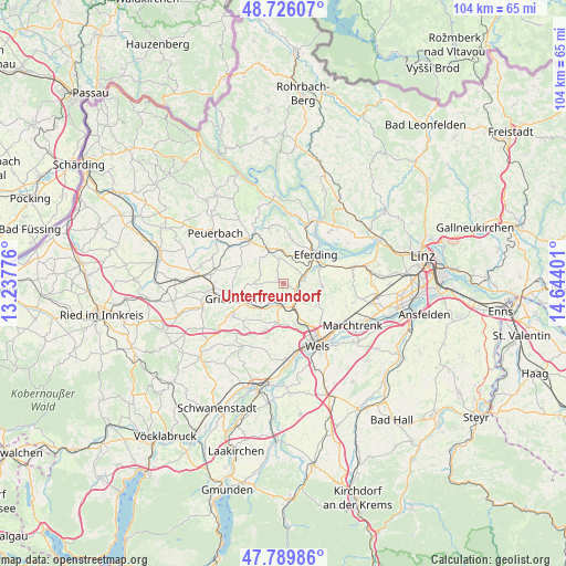
Unterfreundorf GPS coordinates[2]
48° 15' 36.396" North, 13° 56' 27.168" East
| Map corner | latitude | longitude |
|---|---|---|
| Upper-left | 48.72607°, | 13.23776° |
| Center: | 48.26011°, | 13.94088° |
| Lower-right: | 47.78986°, | 14.64401° |
| Map W x H: | 104.1×104.1 km | = 64.7×64.7mi |
| max Lat: | 48.98333° ⇑16.6% North |
| Unterfreundorf: | 48.26011° |
| min Lat: | ⇓83.4% South 46.48841° |
| min Long | Unterfreundorf | max Long |
| 9.57802° | 13.94088° | 17.1° |
| W 33.8%⇐ | ⇒66.2% E |
Elevation
Elevation of Unterfreundorf is 306 m = 1004 ft, and this is 199.5 m = 655 ft below average elevation for this country.
| Max E: |
2140 m = 7021 ft | 74.6% |
| Avg. | 505.5 m = 1658 ft | |
| Unterfreundorf | 306 m = 1004 ft | |
Min E: |
118 m = 387 ft | 25.4% |
See also: Austria elevation on elevation.city.
Geographical zone
Unterfreundorf is located in North temperate zone (between Tropic of Cancer and the Arctic Circle). Distance of this North polar circle is 2035.2 km =1264.6 mi to North.| Distance of | km | miles | from Unterfreundorf |
|---|---|---|---|
| North Pole | 4641 | 2883.8 | to North |
| Arctic Circle | 2035.2 | 1264.6 | to North |
| Tropic Cancer | 2760.1 | 1715 | to South |
| Equator | 5366 | 3334.3 | to South |


Nearby cities:
15 places around Unterfreundorf: (largest is in red/bold)
• Bad Schallerbach
3.7 km =2.3 mi,  205°
205°
• Buchkirchen
7.2 km =4.5 mi,  123°
123°
• Eferding
8.1 km =5 mi,  48°
48°
• Fraham
7.1 km =4.4 mi,  68°
68°
• Grieskirchen
8.5 km =5.3 mi,  249°
249°
• Krenglbach
6.2 km =3.9 mi,  169°
169°
• Michaelnbach
8.7 km =5.4 mi,  290°
290°
• Niederthan
9.6 km =6 mi,  152°
152°
• Oberhaid
10.8 km =6.7 mi, 149°
• Pichl bei Wels
8.9 km =5.5 mi,  200°
200°
• Prambachkirchen
6.9 km =4.3 mi,  336°
336°
• Sankt Marienkirchen an der Polsenz
0.9 km =0.6 mi,  309°
309°
• Schlüsslberg
6.9 km =4.3 mi,  228°
228°
• Waizenkirchen
9.9 km =6.2 mi,  321°
321°
• Wallern an der Trattnach
3 km =1.9 mi, 172°
Sources, notices
• [Note1] Compared only with cities in Austria existing in our database
• [Src1] Map data: © OpenStreetMap contributors (CC-BY-SA)
• [Src2] Other city data from geonames.org with taken over terms of usage.
• [Src3] Geographical zone / Annual Mean Temperature by Robert A. Rohde @ Wikipedia
