Krenglbach geodata
Krenglbach (Upper Austria) is a populated place; located in Austria in Europe/Vienna (GMT+2) time zone. With population of 583 people, there are 2196 cities with bigger population in this country. Compared to other cities in Austria, 79.7% of cities are located further ↓South; 65.9% of cities are located further →East and 74.1% of cities have higher elevation than Krenglbach. Note1


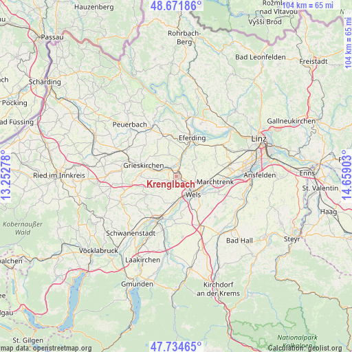
Krenglbach GPS coordinates[2]
48° 12' 19.44" North, 13° 57' 21.24" East
| Map corner | latitude | longitude |
|---|---|---|
| Upper-left | 48.67186°, | 13.25278° |
| Center: | 48.2054°, | 13.9559° |
| Lower-right: | 47.73465°, | 14.65903° |
| Map W x H: | 104.2×104.2 km | = 64.7×64.7mi |
| max Lat: | 48.98333° ⇑20.3% North |
| Krenglbach: | 48.2054° |
| min Lat: | ⇓79.7% South 46.48841° |
| min Long | Krenglbach | max Long |
| 9.57802° | 13.9559° | 17.1° |
| W 34.1%⇐ | ⇒65.9% E |
Elevation
Elevation of Krenglbach is 309 m = 1014 ft, and this is 196.5 m = 645 ft below average elevation for this country.
| Max E: |
2140 m = 7021 ft | 74.1% |
| Avg. | 505.5 m = 1658 ft | |
| Krenglbach | 309 m = 1014 ft | |
Min E: |
118 m = 387 ft | 25.9% |
See also: Austria elevation on elevation.city.
Geographical zone
Krenglbach is located in North temperate zone (between Tropic of Cancer and the Arctic Circle). Distance of this North polar circle is 2041.2 km =1268.3 mi to North.| Distance of | km | miles | from Krenglbach |
|---|---|---|---|
| North Pole | 4647.1 | 2887.6 | to North |
| Arctic Circle | 2041.2 | 1268.3 | to North |
| Tropic Cancer | 2754 | 1711.3 | to South |
| Equator | 5359.9 | 3330.5 | to South |


Nearby cities:
15 places around Krenglbach: (largest is in red/bold)
• Bad Schallerbach
3.9 km =2.4 mi,  315°
315°
• Bernardin
6.3 km =3.9 mi,  142°
142°
• Buchkirchen
5.4 km =3.4 mi,  66°
66°
• Laahen
5.3 km =3.3 mi,  134°
134°
• Lichtenegg
7 km =4.3 mi,  152°
152°
• Niederthan
4.1 km =2.5 mi, 126°
• Oberhaid
5.5 km =3.4 mi, 126°
• Pichl bei Wels
4.8 km =3 mi,  241°
241°
• Sankt Marienkirchen an der Polsenz
6.9 km =4.3 mi,  344°
344°
• Schlüsslberg
6.4 km =4 mi,  283°
283°
• Unterfreundorf
6.2 km =3.9 mi,  349°
349°
• Wallern an der Trattnach
3.1 km =1.9 mi, 346°
• Wels
7.2 km =4.5 mi, 126°
• Wimpassing
4.8 km =3 mi, 154°
• Wispl
5.5 km =3.4 mi, 145°
Sources, notices
• [Note1] Compared only with cities in Austria existing in our database
• [Src1] Map data: © OpenStreetMap contributors (CC-BY-SA)
• [Src2] Other city data from geonames.org with taken over terms of usage.
• [Src3] Geographical zone / Annual Mean Temperature by Robert A. Rohde @ Wikipedia
