Scharndorf geodata
Scharndorf (Lower Austria) is a seat of a third-order administrative division; located in Austria in Europe/Vienna (GMT+2) time zone. With population of 408 people, there are 2609 cities with bigger population in this country. Compared to other cities in Austria, 72.3% of cities are located further ↓South; 98.3% of cities are located further ←West and 93.6% of cities have higher elevation than Scharndorf. Note1
Administrative division(s):
- Level 1: Lower Austria
- Level 2: Politischer Bezirk Bruck an der Leitha
- Level 3: Scharndorf


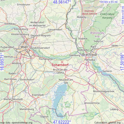
Scharndorf GPS coordinates[2]
48° 5' 38.364" North, 16° 47' 55.788" East
| Map corner | latitude | longitude |
|---|---|---|
| Upper-left | 48.56147°, | 16.09571° |
| Center: | 48.09399°, | 16.79883° |
| Lower-right: | 47.62222°, | 17.50196° |
| Map W x H: | 104.4×104.4 km | = 64.9×64.9mi |
| max Lat: | 48.98333° ⇑27.7% North |
| Scharndorf: | 48.09399° |
| min Lat: | ⇓72.3% South 46.48841° |
| min Long | Scharndorf | max Long |
| 9.57802° | 16.79883° | 17.1° |
| W 98.3%⇐ | ⇒1.7% E |
Elevation
Elevation of Scharndorf is 188 m = 617 ft, and this is 317.5 m = 1042 ft below average elevation for this country.
| Max E: |
2140 m = 7021 ft | 93.6% |
| Avg. | 505.5 m = 1658 ft | |
| Scharndorf | 188 m = 617 ft | |
Min E: |
118 m = 387 ft | 6.4% |
See also: Austria elevation on elevation.city.
Geographical zone
Scharndorf is located in North temperate zone (between Tropic of Cancer and the Arctic Circle). Distance of this North polar circle is 2053.6 km =1276 mi to North.| Distance of | km | miles | from Scharndorf |
|---|---|---|---|
| North Pole | 4659.5 | 2895.3 | to North |
| Arctic Circle | 2053.6 | 1276 | to North |
| Tropic Cancer | 2741.6 | 1703.6 | to South |
| Equator | 5347.6 | 3322.8 | to South |


Nearby cities:
15 places around Scharndorf: (largest is in red/bold)
• Arbesthal
7.9 km =4.9 mi,  247°
247°
• Bad Deutsch-Altenburg
9.1 km =5.7 mi,  60°
60°
• Bruck an der Leitha
8.9 km =5.5 mi,  195°
195°
• Bruckneudorf
8.7 km =5.4 mi,  187°
187°
• Eckartsau
5.7 km =3.5 mi,  358°
358°
• Göttlesbrunn
6.9 km =4.3 mi,  224°
224°
• Haslau an der Donau
6.6 km =4.1 mi,  292°
292°
• Hundsheim
10.5 km =6.5 mi,  75°
75°
• Höflein
3.2 km =2 mi, 200°
• Maria Ellend
8.6 km =5.3 mi,  274°
274°
• Orth an der Donau
9.2 km =5.7 mi,  308°
308°
• Pachfurth
5.1 km =3.2 mi,  164°
164°
• Petronell-Carnuntum
5.4 km =3.4 mi,  67°
67°
• Rohrau
4.9 km =3 mi,  128°
128°
• Wilfleinsdorf
10.5 km =6.5 mi, 215°
Sources, notices
• [Note1] Compared only with cities in Austria existing in our database
• [Src1] Map data: © OpenStreetMap contributors (CC-BY-SA)
• [Src2] Other city data from geonames.org with taken over terms of usage.
• [Src3] Geographical zone / Annual Mean Temperature by Robert A. Rohde @ Wikipedia
