Schachendorf geodata
Schachendorf (Burgenland) is a seat of a third-order administrative division; located in Austria in Europe/Vienna (GMT+2) time zone. With population of 440 people, there are 2575 cities with bigger population in this country. Compared to other cities in Austria, 68.3% of cities are located further ↑North; 92.2% of cities are located further ←West and 79% of cities have higher elevation than Schachendorf. Note1
Administrative division(s):
- Level 1: Burgenland
- Level 2: Politischer Bezirk Oberwart
- Level 3: Schachendorf


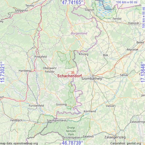
Schachendorf GPS coordinates[2]
47° 16' 0.012" North, 16° 25' 59.988" East
| Map corner | latitude | longitude |
|---|---|---|
| Upper-left | 47.74165°, | 15.73021° |
| Center: | 47.26667°, | 16.43333° |
| Lower-right: | 46.78739°, | 17.13646° |
| Map W x H: | 106.1×106.1 km | = 65.9×65.9mi |
| max Lat: | 48.98333° ⇑68.3% North |
| Schachendorf: | 47.26667° |
| min Lat: | ⇓31.7% South 46.48841° |
| min Long | Schachendorf | max Long |
| 9.57802° | 16.43333° | 17.1° |
| W 92.2%⇐ | ⇒7.8% E |
Elevation
Elevation of Schachendorf is 279 m = 915 ft, and this is 226.5 m = 743 ft below average elevation for this country.
| Max E: |
2140 m = 7021 ft | 79% |
| Avg. | 505.5 m = 1658 ft | |
| Schachendorf | 279 m = 915 ft | |
Min E: |
118 m = 387 ft | 21% |
See also: Austria elevation on elevation.city.
Geographical zone
Schachendorf is located in North temperate zone (between Tropic of Cancer and the Arctic Circle). Distance of this North polar circle is 2145.6 km =1333.2 mi to North.| Distance of | km | miles | from Schachendorf |
|---|---|---|---|
| North Pole | 4751.5 | 2952.4 | to North |
| Arctic Circle | 2145.6 | 1333.2 | to North |
| Tropic Cancer | 2649.6 | 1646.4 | to South |
| Equator | 5255.6 | 3265.7 | to South |


Nearby cities:
15 places around Schachendorf: (largest is in red/bold)
• Badersdorf
9 km =5.6 mi,  214°
214°
• Grosspetersdorf
9.2 km =5.7 mi,  250°
250°
• Hannersdorf
5.7 km =3.5 mi,  222°
222°
• Jabing
12.2 km =7.6 mi,  255°
255°
• Kohfidisch
11.7 km =7.3 mi, 209°
• Lockenhaus
15.7 km =9.8 mi,  355°
355°
• Markt Neuhodis
4.3 km =2.7 mi,  318°
318°
• Mischendorf
12.2 km =7.6 mi,  227°
227°
• Rechnitz
4.3 km =2.7 mi,  7°
7°
• Rotenturm an der Pinka
14 km =8.7 mi, 262°
• Schandorf
2.9 km =1.8 mi,  196°
196°
• Stadtschlaining
12.6 km =7.8 mi,  296°
296°
• Unterkohlstätten
15.7 km =9.8 mi,  325°
325°
• Unterwart
15.2 km =9.4 mi, 262°
• Weiden bei Rechnitz
7.3 km =4.5 mi, 300°
Sources, notices
• [Note1] Compared only with cities in Austria existing in our database
• [Src1] Map data: © OpenStreetMap contributors (CC-BY-SA)
• [Src2] Other city data from geonames.org with taken over terms of usage.
• [Src3] Geographical zone / Annual Mean Temperature by Robert A. Rohde @ Wikipedia
