Jabing geodata
Jabing (Burgenland) is a seat of a third-order administrative division; located in Austria in Europe/Vienna (GMT+2) time zone. With population of 734 people, there are 1763 cities with bigger population in this country. Compared to other cities in Austria, 69.8% of cities are located further ↑North; 88.1% of cities are located further ←West and 79.5% of cities have higher elevation than Jabing. Note1
Administrative division(s):
- Level 1: Burgenland
- Level 2: Politischer Bezirk Oberwart
- Level 3: Jabing


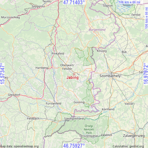
Jabing GPS coordinates[2]
47° 14' 19.68" North, 16° 16' 35.724" East
| Map corner | latitude | longitude |
|---|---|---|
| Upper-left | 47.71403°, | 15.57347° |
| Center: | 47.2388°, | 16.27659° |
| Lower-right: | 46.75927°, | 16.97972° |
| Map W x H: | 106.2×106.2 km | = 66×66mi |
| max Lat: | 48.98333° ⇑69.8% North |
| Jabing: | 47.2388° |
| min Lat: | ⇓30.2% South 46.48841° |
| min Long | Jabing | max Long |
| 9.57802° | 16.27659° | 17.1° |
| W 88.1%⇐ | ⇒11.9% E |
Elevation
Elevation of Jabing is 277 m = 909 ft, and this is 228.5 m = 750 ft below average elevation for this country.
| Max E: |
2140 m = 7021 ft | 79.5% |
| Avg. | 505.5 m = 1658 ft | |
| Jabing | 277 m = 909 ft | |
Min E: |
118 m = 387 ft | 20.5% |
See also: Austria elevation on elevation.city.
Geographical zone
Jabing is located in North temperate zone (between Tropic of Cancer and the Arctic Circle). Distance of this North polar circle is 2148.7 km =1335.1 mi to North.| Distance of | km | miles | from Jabing |
|---|---|---|---|
| North Pole | 4754.6 | 2954.4 | to North |
| Arctic Circle | 2148.7 | 1335.1 | to North |
| Tropic Cancer | 2646.5 | 1644.5 | to South |
| Equator | 5252.5 | 3263.8 | to South |


Nearby cities:
15 places around Jabing: (largest is in red/bold)
• Badersdorf
8.1 km =5 mi,  122°
122°
• Grosspetersdorf
3.1 km =1.9 mi,  89°
89°
• Güttenbach
9.2 km =5.7 mi,  172°
172°
• Hannersdorf
8.1 km =5 mi,  97°
97°
• Kohfidisch
9.4 km =5.8 mi,  139°
139°
• Litzelsdorf
8.6 km =5.3 mi,  246°
246°
• Mischendorf
5.9 km =3.7 mi,  150°
150°
• Neuberg im Burgenland
7.9 km =4.9 mi,  188°
188°
• Oberdorf im Burgenland
5.2 km =3.2 mi,  241°
241°
• Oberwart
7.8 km =4.8 mi,  316°
316°
• Olbendorf
8.5 km =5.3 mi,  223°
223°
• Rotenturm an der Pinka
2.4 km =1.5 mi,  301°
301°
• Stadtschlaining
8.7 km =5.4 mi,  3°
3°
• Unterwart
3.5 km =2.2 mi,  290°
290°
• Weiden bei Rechnitz
8.8 km =5.5 mi,  39°
39°
Sources, notices
• [Note1] Compared only with cities in Austria existing in our database
• [Src1] Map data: © OpenStreetMap contributors (CC-BY-SA)
• [Src2] Other city data from geonames.org with taken over terms of usage.
• [Src3] Geographical zone / Annual Mean Temperature by Robert A. Rohde @ Wikipedia
