Sankt Ruprecht an der Raab geodata
Sankt Ruprecht an der Raab (Styria) is a seat of a third-order administrative division; located in Austria in Europe/Vienna (GMT+2) time zone. With population of 1,231 people, there are 1022 cities with bigger population in this country. Compared to other cities in Austria, 75.3% of cities are located further ↑North; 70.8% of cities are located further ←West and 60.3% of cities have higher elevation than Sankt Ruprecht an der Raab. Note1
Administrative division(s):
- Level 1: Styria
- Level 2: Politischer Bezirk Weiz
- Level 3: Sankt Ruprecht an der Raab
Current local time in Sankt Ruprecht an der Raab:
01:21 AM, SaturdayDifference from your time zone: hours


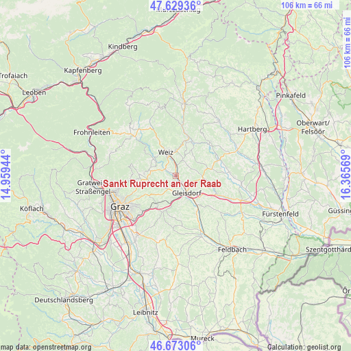
Sankt Ruprecht an der Raab GPS coordinates[2]
47° 9' 12.096" North, 15° 39' 45.216" East
| Map corner | latitude | longitude |
|---|---|---|
| Upper-left | 47.62936°, | 14.95944° |
| Center: | 47.15336°, | 15.66256° |
| Lower-right: | 46.67306°, | 16.36569° |
| Map W x H: | 106.3×106.3 km | = 66.1×66.1mi |
| max Lat: | 48.98333° ⇑75.3% North |
| Sankt Ruprecht an der Raab: | 47.15336° |
| min Lat: | ⇓24.7% South 46.48841° |
| min Long | Sankt Ruprecht | max Long |
| 9.57802° | 15.66256° | 17.1° |
| W 70.8%⇐ | ⇒29.2% E |
Elevation
Elevation of Sankt Ruprecht an der Raab is 381 m = 1250 ft, and this is 124.5 m = 408 ft below average elevation for this country.
| Max E: |
2140 m = 7021 ft | 60.3% |
| Avg. | 505.5 m = 1658 ft | |
| Sankt Ruprecht an der Raab | 381 m = 1250 ft | |
Min E: |
118 m = 387 ft | 39.7% |
See also: Austria elevation on elevation.city.
Geographical zone
Sankt Ruprecht an der Raab is located in North temperate zone (between Tropic of Cancer and the Arctic Circle). Distance of this North polar circle is 2158.2 km =1341 mi to North.| Distance of | km | miles | from Sankt Ruprecht an der Raab |
|---|---|---|---|
| North Pole | 4764.1 | 2960.3 | to North |
| Arctic Circle | 2158.2 | 1341 | to North |
| Tropic Cancer | 2637 | 1638.6 | to South |
| Equator | 5243 | 3257.8 | to South |


Nearby cities:
15 places around Sankt Ruprecht an der Raab: (largest is in red/bold)
• Albersdorf
4.4 km =2.7 mi,  142°
142°
• Brodersdorf
5.4 km =3.4 mi,  220°
220°
• Eggersdorf bei Graz
5.7 km =3.5 mi,  234°
234°
• Etzersdorf
5.4 km =3.4 mi,  16°
16°
• Fünfing bei Sankt Ruprecht an der Raab
2.4 km =1.5 mi,  203°
203°
• Gleisdorf
6.4 km =4 mi,  145°
145°
• Gschwendt
7.4 km =4.6 mi,  292°
292°
• Hart bei Eggersdorf
7.6 km =4.7 mi,  252°
252°
• Krottendorf
5.6 km =3.5 mi,  336°
336°
• Ludersdorf
5.9 km =3.7 mi,  159°
159°
• Mitterdorf an der Raab
5 km =3.1 mi, 287°
• Preding
3.5 km =2.2 mi, 344°
• Unterfladnitz
3.3 km =2.1 mi,  5°
5°
• Wilfersdorf bei Gleisdorf
5.9 km =3.7 mi,  177°
177°
• Wünschendorf
7.2 km =4.5 mi, 145°
Sources, notices
• [Note1] Compared only with cities in Austria existing in our database
• [Src1] Map data: © OpenStreetMap contributors (CC-BY-SA)
• [Src2] Other city data from geonames.org with taken over terms of usage.
• [Src3] Geographical zone / Annual Mean Temperature by Robert A. Rohde @ Wikipedia
