Reichendorf geodata
Reichendorf (Styria) is a seat of a third-order administrative division; located in Austria in Europe/Vienna (GMT+2) time zone. With population of 614 people, there are 2083 cities with bigger population in this country. Compared to other cities in Austria, 73.4% of cities are located further ↑North; 73.7% of cities are located further ←West and 51.2% of cities have lower elevation than Reichendorf. Note1
Administrative division(s):
- Level 1: Styria
- Level 2: Politischer Bezirk Weiz
- Level 3: Pischelsdorf am Kulm


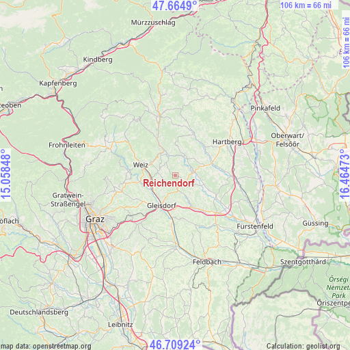
Reichendorf GPS coordinates[2]
47° 11' 21.192" North, 15° 45' 41.76" East
| Map corner | latitude | longitude |
|---|---|---|
| Upper-left | 47.6649°, | 15.05848° |
| Center: | 47.18922°, | 15.7616° |
| Lower-right: | 46.70924°, | 16.46473° |
| Map W x H: | 106.3×106.3 km | = 66.1×66.1mi |
| max Lat: | 48.98333° ⇑73.4% North |
| Reichendorf: | 47.18922° |
| min Lat: | ⇓26.6% South 46.48841° |
| min Long | Reichendorf | max Long |
| 9.57802° | 15.7616° | 17.1° |
| W 73.7%⇐ | ⇒26.3% E |
Elevation
Elevation of Reichendorf is 458 m = 1503 ft, and this is 47.5 m = 156 ft below average elevation for this country.
| Max E: |
2140 m = 7021 ft | 48.8% |
| Avg. | 505.5 m = 1658 ft | |
| Reichendorf | 458 m = 1503 ft | |
Min E: |
118 m = 387 ft | 51.2% |
See also: Austria elevation on elevation.city.
Geographical zone
Reichendorf is located in North temperate zone (between Tropic of Cancer and the Arctic Circle). Distance of this North polar circle is 2154.2 km =1338.6 mi to North.| Distance of | km | miles | from Reichendorf |
|---|---|---|---|
| North Pole | 4760.1 | 2957.8 | to North |
| Arctic Circle | 2154.2 | 1338.6 | to North |
| Tropic Cancer | 2641 | 1641 | to South |
| Equator | 5246.9 | 3260.3 | to South |


Nearby cities:
15 places around Reichendorf: (largest is in red/bold)
• Blaindorf
8.2 km =5.1 mi,  101°
101°
• Etzersdorf
6 km =3.7 mi,  281°
281°
• Gersdorf an der Feistritz
7.1 km =4.4 mi,  110°
110°
• Hirnsdorf
5.1 km =3.2 mi,  86°
86°
• Kaibing
5.6 km =3.5 mi,  77°
77°
• Nitscha
8.1 km =5 mi,  186°
186°
• Oberrettenbach
5.2 km =3.2 mi,  146°
146°
• Pischelsdorf in der Steiermark
3.7 km =2.3 mi,  116°
116°
• Prebensdorf
6.4 km =4 mi,  165°
165°
• Puch bei Weiz
4.6 km =2.9 mi,  311°
311°
• Sankt Johann bei Herberstein
3.1 km =1.9 mi,  67°
67°
• Siegersdorf bei Herberstein
2 km =1.2 mi,  53°
53°
• Stubenberg
6.8 km =4.2 mi,  25°
25°
• Unterfladnitz
7.2 km =4.5 mi,  264°
264°
• Zeil
7 km =4.3 mi,  13°
13°
Sources, notices
• [Note1] Compared only with cities in Austria existing in our database
• [Src1] Map data: © OpenStreetMap contributors (CC-BY-SA)
• [Src2] Other city data from geonames.org with taken over terms of usage.
• [Src3] Geographical zone / Annual Mean Temperature by Robert A. Rohde @ Wikipedia
