Nitscha geodata
Nitscha (Styria) is a seat of a third-order administrative division; located in Austria in Europe/Vienna (GMT+1) time zone. With population of 750 people, there are 1723 cities with bigger population in this country. Compared to other cities in Austria, 78.3% of cities are located further ↑North; 73.3% of cities are located further ←West and 54.5% of cities have higher elevation than Nitscha. Note1


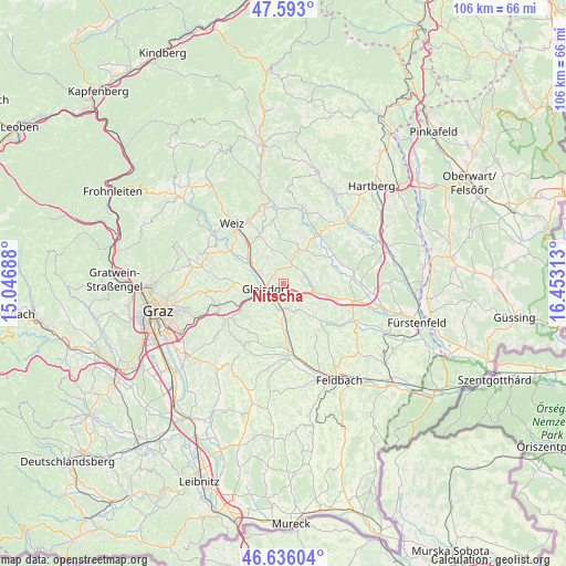
Nitscha GPS coordinates[2]
47° 7' 0.012" North, 15° 45' 0" East
| Map corner | latitude | longitude |
|---|---|---|
| Upper-left | 47.593°, | 15.04688° |
| Center: | 47.11667°, | 15.75° |
| Lower-right: | 46.63604°, | 16.45313° |
| Map W x H: | 106.4×106.4 km | = 66.1×66.1mi |
| max Lat: | 48.98333° ⇑78.3% North |
| Nitscha: | 47.11667° |
| min Lat: | ⇓21.7% South 46.48841° |
| min Long | Nitscha | max Long |
| 9.57802° | 15.75° | 17.1° |
| W 73.3%⇐ | ⇒26.7% E |
Elevation
Elevation of Nitscha is 424 m = 1391 ft, and this is 81.5 m = 267 ft below average elevation for this country.
| Max E: |
2140 m = 7021 ft | 54.5% |
| Avg. | 505.5 m = 1658 ft | |
| Nitscha | 424 m = 1391 ft | |
Min E: |
118 m = 387 ft | 45.5% |
See also: Austria elevation on elevation.city.
Geographical zone
Nitscha is located in North temperate zone (between Tropic of Cancer and the Arctic Circle). Distance of this North polar circle is 2162.3 km =1343.6 mi to North.| Distance of | km | miles | from Nitscha |
|---|---|---|---|
| North Pole | 4768.2 | 2962.8 | to North |
| Arctic Circle | 2162.3 | 1343.6 | to North |
| Tropic Cancer | 2633 | 1636.1 | to South |
| Equator | 5238.9 | 3255.3 | to South |


Nearby cities:
15 places around Nitscha: (largest is in red/bold)
• Albersdorf
4 km =2.5 mi,  278°
278°
• Egelsdorf
5 km =3.1 mi,  90°
90°
• Flöcking
7.3 km =4.5 mi,  239°
239°
• Gleisdorf
3.3 km =2.1 mi,  247°
247°
• Hofstätten an der Raab
5.7 km =3.5 mi,  192°
192°
• Ludersdorf
4.8 km =3 mi, 252°
• Oberrettenbach
5.3 km =3.3 mi,  45°
45°
• Prebensdorf
3.1 km =1.9 mi, 53°
• Pöllau bei Gleisdorf
6.7 km =4.2 mi,  145°
145°
• Sinabelkirchen
6.1 km =3.8 mi,  105°
105°
• Sulz bei Gleisdorf
5.7 km =3.5 mi, 192°
• Ungerdorf
7.3 km =4.5 mi, 239°
• Untergroßau
4.9 km =3 mi, 110°
• Wilfersdorf bei Gleisdorf
6.6 km =4.1 mi, 253°
• Wünschendorf
3.1 km =1.9 mi,  233°
233°
Sources, notices
• [Note1] Compared only with cities in Austria existing in our database
• [Src1] Map data: © OpenStreetMap contributors (CC-BY-SA)
• [Src2] Other city data from geonames.org with taken over terms of usage.
• [Src3] Geographical zone / Annual Mean Temperature by Robert A. Rohde @ Wikipedia
