Prebensdorf geodata
Prebensdorf (Styria) is a populated place; located in Austria in Europe/Vienna (GMT+2) time zone. With population of 720 people, there are 1801 cities with bigger population in this country. Compared to other cities in Austria, 77.2% of cities are located further ↑North; 74.2% of cities are located further ←West and 60.1% of cities have higher elevation than Prebensdorf. Note1


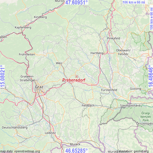
Prebensdorf GPS coordinates[2]
47° 7' 59.988" North, 15° 46' 59.988" East
| Map corner | latitude | longitude |
|---|---|---|
| Upper-left | 47.60951°, | 15.08021° |
| Center: | 47.13333°, | 15.78333° |
| Lower-right: | 46.65285°, | 16.48646° |
| Map W x H: | 106.4×106.4 km | = 66.1×66.1mi |
| max Lat: | 48.98333° ⇑77.2% North |
| Prebensdorf: | 47.13333° |
| min Lat: | ⇓22.8% South 46.48841° |
| min Long | Prebensdorf | max Long |
| 9.57802° | 15.78333° | 17.1° |
| W 74.2%⇐ | ⇒25.8% E |
Elevation
Elevation of Prebensdorf is 382 m = 1253 ft, and this is 123.5 m = 405 ft below average elevation for this country.
| Max E: |
2140 m = 7021 ft | 60.1% |
| Avg. | 505.5 m = 1658 ft | |
| Prebensdorf | 382 m = 1253 ft | |
Min E: |
118 m = 387 ft | 39.9% |
See also: Austria elevation on elevation.city.
Geographical zone
Prebensdorf is located in North temperate zone (between Tropic of Cancer and the Arctic Circle). Distance of this North polar circle is 2160.4 km =1342.4 mi to North.| Distance of | km | miles | from Prebensdorf |
|---|---|---|---|
| North Pole | 4766.3 | 2961.6 | to North |
| Arctic Circle | 2160.4 | 1342.4 | to North |
| Tropic Cancer | 2634.8 | 1637.2 | to South |
| Equator | 5240.7 | 3256.4 | to South |


Nearby cities:
15 places around Prebensdorf: (largest is in red/bold)
• Albersdorf
6.6 km =4.1 mi,  258°
258°
• Egelsdorf
3.1 km =1.9 mi,  126°
126°
• Gersdorf an der Feistritz
6.3 km =3.9 mi,  53°
53°
• Gleisdorf
6.3 km =3.9 mi,  240°
240°
• Gnies
6.3 km =3.9 mi, 126°
• Hirnsdorf
7.3 km =4.5 mi,  27°
27°
• Nitscha
3.1 km =1.9 mi,  233°
233°
• Oberrettenbach
2.2 km =1.4 mi, 34°
• Pischelsdorf in der Steiermark
4.8 km =3 mi,  20°
20°
• Reichendorf
6.4 km =4 mi,  345°
345°
• Sankt Johann bei Herberstein
7.5 km =4.7 mi,  9°
9°
• Siegersdorf bei Herberstein
7.4 km =4.6 mi,  0°
0°
• Sinabelkirchen
4.9 km =3 mi,  135°
135°
• Untergroßau
4.1 km =2.5 mi,  149°
149°
• Wünschendorf
6.3 km =3.9 mi, 233°
Sources, notices
• [Note1] Compared only with cities in Austria existing in our database
• [Src1] Map data: © OpenStreetMap contributors (CC-BY-SA)
• [Src2] Other city data from geonames.org with taken over terms of usage.
• [Src3] Geographical zone / Annual Mean Temperature by Robert A. Rohde @ Wikipedia
