Pubersdorf geodata
Pubersdorf (Carinthia) is a populated place; located in Austria in Europe/Vienna (GMT+2) time zone. With population of 547 people, there are 2332 cities with bigger population in this country. Compared to other cities in Austria, 96.6% of cities are located further ↑North; 54.9% of cities are located further →East and 51.1% of cities have higher elevation than Pubersdorf. Note1
Administrative division(s):
- Level 1: Carinthia
- Level 2: Politischer Bezirk Klagenfurt Land
- Level 3: Poggersdorf


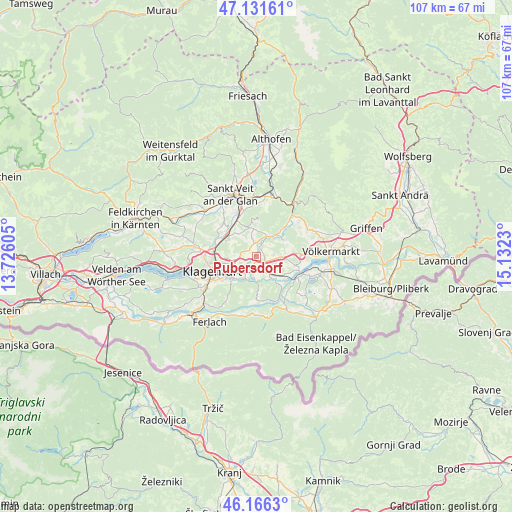
Pubersdorf GPS coordinates[2]
46° 39' 3.996" North, 14° 25' 45.012" East
| Map corner | latitude | longitude |
|---|---|---|
| Upper-left | 47.13161°, | 13.72605° |
| Center: | 46.65111°, | 14.42917° |
| Lower-right: | 46.1663°, | 15.1323° |
| Map W x H: | 107.3×107.3 km | = 66.7×66.7mi |
| max Lat: | 48.98333° ⇑96.6% North |
| Pubersdorf: | 46.65111° |
| min Lat: | ⇓3.4% South 46.48841° |
| min Long | Pubersdorf | max Long |
| 9.57802° | 14.42917° | 17.1° |
| W 45.1%⇐ | ⇒54.9% E |
Elevation
Elevation of Pubersdorf is 445 m = 1460 ft, and this is 60.5 m = 198 ft below average elevation for this country.
| Max E: |
2140 m = 7021 ft | 51.1% |
| Avg. | 505.5 m = 1658 ft | |
| Pubersdorf | 445 m = 1460 ft | |
Min E: |
118 m = 387 ft | 48.9% |
See also: Austria elevation on elevation.city.
Geographical zone
Pubersdorf is located in North temperate zone (between Tropic of Cancer and the Arctic Circle). Distance of this North polar circle is 2214.1 km =1375.8 mi to North.| Distance of | km | miles | from Pubersdorf |
|---|---|---|---|
| North Pole | 4819.9 | 2994.9 | to North |
| Arctic Circle | 2214.1 | 1375.8 | to North |
| Tropic Cancer | 2581.2 | 1603.9 | to South |
| Equator | 5187.1 | 3223.1 | to South |


Nearby cities:
15 places around Pubersdorf: (largest is in red/bold)
• Annabichl
8.6 km =5.3 mi,  269°
269°
• Ebenthal
6.9 km =4.3 mi,  226°
226°
• Grafenstein
5.1 km =3.2 mi,  144°
144°
• Hörtendorf
3 km =1.9 mi, 228°
• Karnburg
9.5 km =5.9 mi,  293°
293°
• Leibsdorf
3.5 km =2.2 mi,  85°
85°
• Maria Saal
7 km =4.3 mi,  298°
298°
• Niederdorf
4.4 km =2.7 mi,  210°
210°
• Pischeldorf
3.9 km =2.4 mi,  23°
23°
• Poggersdorf
1.6 km =1 mi, 94°
• Rain
6.1 km =3.8 mi, 212°
• Reichersdorf
7.4 km =4.6 mi,  220°
220°
• Sankt Peter
7.2 km =4.5 mi,  250°
250°
• Tainach
8.2 km =5.1 mi,  103°
103°
• Völkermarkter Vorstadt
8.8 km =5.5 mi, 250°
Sources, notices
• [Note1] Compared only with cities in Austria existing in our database
• [Src1] Map data: © OpenStreetMap contributors (CC-BY-SA)
• [Src2] Other city data from geonames.org with taken over terms of usage.
• [Src3] Geographical zone / Annual Mean Temperature by Robert A. Rohde @ Wikipedia
