Maria Saal geodata
Maria Saal (Carinthia) is a seat of a third-order administrative division; located in Austria in Europe/Vienna (GMT+2) time zone. With population of 1,094 people, there are 1167 cities with bigger population in this country. Compared to other cities in Austria, 96.1% of cities are located further ↑North; 56.8% of cities are located further →East and 58.2% of cities have lower elevation than Maria Saal. Note1
Administrative division(s):
- Level 1: Carinthia
- Level 2: Politischer Bezirk Klagenfurt Land
- Level 3: Maria Saal


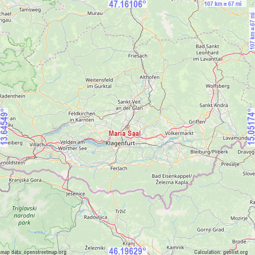
Maria Saal GPS coordinates[2]
46° 40' 50.988" North, 14° 20' 54.996" East
| Map corner | latitude | longitude |
|---|---|---|
| Upper-left | 47.16106°, | 13.64549° |
| Center: | 46.68083°, | 14.34861° |
| Lower-right: | 46.19629°, | 15.05174° |
| Map W x H: | 107.3×107.3 km | = 66.7×66.7mi |
| max Lat: | 48.98333° ⇑96.1% North |
| Maria Saal: | 46.68083° |
| min Lat: | ⇓3.9% South 46.48841° |
| min Long | Maria Saal | max Long |
| 9.57802° | 14.34861° | 17.1° |
| W 43.2%⇐ | ⇒56.8% E |
Elevation
Elevation of Maria Saal is 507 m = 1663 ft, and this is 1.5 m = 5 ft above average elevation for this country.
| Max E: |
2140 m = 7021 ft | 41.8% |
| Maria Saal | 507 m 1663 ft | |
| Avg. | 505.5 m = 1658 ft | |
Min E: |
118 m = 387 ft | 58.2% |
See also: Austria elevation on elevation.city.
Geographical zone
Maria Saal is located in North temperate zone (between Tropic of Cancer and the Arctic Circle). Distance of this North polar circle is 2210.8 km =1373.7 mi to North.| Distance of | km | miles | from Maria Saal |
|---|---|---|---|
| North Pole | 4816.6 | 2992.9 | to North |
| Arctic Circle | 2210.8 | 1373.7 | to North |
| Tropic Cancer | 2584.5 | 1605.9 | to South |
| Equator | 5190.4 | 3225.2 | to South |


Nearby cities:
15 places around Maria Saal: (largest is in red/bold)
• 2.Bezirk
6.9 km =4.3 mi,  205°
205°
• 3.Bezirk
7.1 km =4.4 mi,  204°
204°
• 4.Bezirk
7.3 km =4.5 mi, 206°
• Annabichl
4.2 km =2.6 mi,  215°
215°
• Hörtendorf
6.6 km =4.1 mi,  143°
143°
• Innere Stadt
7 km =4.3 mi, 206°
• Karnburg
2.6 km =1.6 mi,  280°
280°
• Klagenfurt am Wörthersee
7.1 km =4.4 mi, 207°
• Pischeldorf
7.7 km =4.8 mi,  87°
87°
• Pubersdorf
7 km =4.3 mi,  118°
118°
• Sankt Peter
5.7 km =3.5 mi,  186°
186°
• St. Veiter Vorstadt
6.4 km =4 mi, 210°
• Viktringer Vorstadt
7.6 km =4.7 mi, 203°
• Völkermarkter Vorstadt
6.6 km =4.1 mi, 198°
• Wölfnitz
7.1 km =4.4 mi,  256°
256°
Sources, notices
• [Note1] Compared only with cities in Austria existing in our database
• [Src1] Map data: © OpenStreetMap contributors (CC-BY-SA)
• [Src2] Other city data from geonames.org with taken over terms of usage.
• [Src3] Geographical zone / Annual Mean Temperature by Robert A. Rohde @ Wikipedia
