Grafenstein geodata
Grafenstein (Carinthia) is a seat of a third-order administrative division; located in Austria in Europe/Vienna (GMT+2) time zone. With population of 989 people, there are 1314 cities with bigger population in this country. Compared to other cities in Austria, 98.1% of cities are located further ↑North; 54% of cities are located further →East and 55.5% of cities have higher elevation than Grafenstein. Note1
Administrative division(s):
- Level 1: Carinthia
- Level 2: Politischer Bezirk Klagenfurt Land
- Level 3: Grafenstein


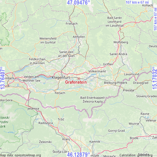
Grafenstein GPS coordinates[2]
46° 36' 50.148" North, 14° 28' 1.884" East
| Map corner | latitude | longitude |
|---|---|---|
| Upper-left | 47.09476°, | 13.76407° |
| Center: | 46.61393°, | 14.46719° |
| Lower-right: | 46.12879°, | 15.17032° |
| Map W x H: | 107.4×107.4 km | = 66.7×66.7mi |
| max Lat: | 48.98333° ⇑98.1% North |
| Grafenstein: | 46.61393° |
| min Lat: | ⇓1.9% South 46.48841° |
| min Long | Grafenstein | max Long |
| 9.57802° | 14.46719° | 17.1° |
| W 46%⇐ | ⇒54% E |
Elevation
Elevation of Grafenstein is 415 m = 1362 ft, and this is 90.5 m = 297 ft below average elevation for this country.
| Max E: |
2140 m = 7021 ft | 55.5% |
| Avg. | 505.5 m = 1658 ft | |
| Grafenstein | 415 m = 1362 ft | |
Min E: |
118 m = 387 ft | 44.5% |
See also: Austria elevation on elevation.city.
Geographical zone
Grafenstein is located in North temperate zone (between Tropic of Cancer and the Arctic Circle). Distance of this North polar circle is 2218.2 km =1378.3 mi to North.| Distance of | km | miles | from Grafenstein |
|---|---|---|---|
| North Pole | 4824.1 | 2997.6 | to North |
| Arctic Circle | 2218.2 | 1378.3 | to North |
| Tropic Cancer | 2577.1 | 1601.3 | to South |
| Equator | 5183 | 3220.6 | to South |


Nearby cities:
15 places around Grafenstein: (largest is in red/bold)
• Ebenthal
7.9 km =4.9 mi,  265°
265°
• Gallizien
8.1 km =5 mi,  151°
151°
• Hörtendorf
5.6 km =3.5 mi,  292°
292°
• Leibsdorf
4.4 km =2.7 mi,  7°
7°
• Niederdorf
5.1 km =3.2 mi, 273°
• Pischeldorf
7.8 km =4.8 mi,  350°
350°
• Poggersdorf
4.2 km =2.6 mi,  341°
341°
• Pubersdorf
5.1 km =3.2 mi,  324°
324°
• Rain
6.3 km =3.9 mi,  261°
261°
• Reichersdorf
7.8 km =4.8 mi, 258°
• Sankt Margareten im Rosental
8.4 km =5.2 mi,  202°
202°
• Sankt Peter
9.9 km =6.2 mi,  280°
280°
• Tainach
5.5 km =3.4 mi,  66°
66°
• Völkermarkter Vorstadt
11.2 km =7 mi, 275°
• Wasserhofen
11.4 km =7.1 mi,  88°
88°
Sources, notices
• [Note1] Compared only with cities in Austria existing in our database
• [Src1] Map data: © OpenStreetMap contributors (CC-BY-SA)
• [Src2] Other city data from geonames.org with taken over terms of usage.
• [Src3] Geographical zone / Annual Mean Temperature by Robert A. Rohde @ Wikipedia
