Pack geodata
Pack (Styria) is a seat of a third-order administrative division; located in Austria in Europe/Vienna (GMT+2) time zone. With population of 410 people, there are 2605 cities with bigger population in this country. Compared to other cities in Austria, 85.2% of cities are located further ↑North; 54.1% of cities are located further ←West and 96.4% of cities have lower elevation than Pack. Note1
Administrative division(s):
- Level 1: Styria
- Level 2: Politischer Bezirk Voitsberg
- Level 3: Hirschegg-Pack


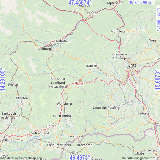
Pack GPS coordinates[2]
46° 58' 45.012" North, 14° 59' 3.012" East
| Map corner | latitude | longitude |
|---|---|---|
| Upper-left | 47.45674°, | 14.28105° |
| Center: | 46.97917°, | 14.98417° |
| Lower-right: | 46.4973°, | 15.6873° |
| Map W x H: | 106.7×106.7 km | = 66.3×66.3mi |
| max Lat: | 48.98333° ⇑85.2% North |
| Pack: | 46.97917° |
| min Lat: | ⇓14.8% South 46.48841° |
| min Long | Pack | max Long |
| 9.57802° | 14.98417° | 17.1° |
| W 54.1%⇐ | ⇒45.9% E |
Elevation
Elevation of Pack is 1094 m = 3589 ft, and this is 588.5 m = 1931 ft above average elevation for this country.
| Max E: |
2140 m = 7021 ft | 3.6% |
| Pack | 1094 m 3589 ft | |
| Avg. | 505.5 m = 1658 ft | |
Min E: |
118 m = 387 ft | 96.4% |
See also: Austria elevation on elevation.city.
Geographical zone
Pack is located in North temperate zone (between Tropic of Cancer and the Arctic Circle). Distance of this North polar circle is 2177.6 km =1353.1 mi to North.| Distance of | km | miles | from Pack |
|---|---|---|---|
| North Pole | 4783.5 | 2972.3 | to North |
| Arctic Circle | 2177.6 | 1353.1 | to North |
| Tropic Cancer | 2617.7 | 1626.6 | to South |
| Equator | 5223.6 | 3245.8 | to South |


Nearby cities:
15 places around Pack: (largest is in red/bold)
• Bad Sankt Leonhard im Lavanttal
14.7 km =9.1 mi,  262°
262°
• Bärnbach
15 km =9.3 mi,  46°
46°
• Edelschrott
7 km =4.3 mi, 47°
• Gradenberg
12.8 km =8 mi,  30°
30°
• Hirschegg Rein
5.1 km =3.2 mi,  335°
335°
• Kloster
13 km =8.1 mi,  144°
144°
• Köflach
12.3 km =7.6 mi,  37°
37°
• Maria Lankowitz
11.1 km =6.9 mi, 33°
• Modriach
6 km =3.7 mi,  122°
122°
• Osterwitz
15.6 km =9.7 mi,  148°
148°
• Pichling bei Köflach
10.1 km =6.3 mi, 40°
• Preitenegg
6.2 km =3.9 mi,  225°
225°
• Rosental an der Kainach
13.2 km =8.2 mi, 52°
• Salla
13.5 km =8.4 mi,  354°
354°
• Voitsberg
14.7 km =9.1 mi,  60°
60°
Sources, notices
• [Note1] Compared only with cities in Austria existing in our database
• [Src1] Map data: © OpenStreetMap contributors (CC-BY-SA)
• [Src2] Other city data from geonames.org with taken over terms of usage.
• [Src3] Geographical zone / Annual Mean Temperature by Robert A. Rohde @ Wikipedia
