Perchtoldsdorf geodata
Perchtoldsdorf (Lower Austria) is a seat of a third-order administrative division; located in Austria in Europe/Vienna (GMT+2) time zone. With population of 15,047 people, there are 47 cities with bigger population in this country. Compared to other cities in Austria, 73.8% of cities are located further ↓South; 87.9% of cities are located further ←West and 83.2% of cities have higher elevation than Perchtoldsdorf. Note1
Administrative division(s):
- Level 1: Lower Austria
- Level 2: Politischer Bezirk Mödling
- Level 3: Perchtoldsdorf


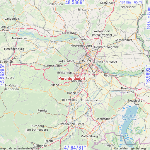
Perchtoldsdorf GPS coordinates[2]
48° 7' 9.66" North, 16° 15' 57.852" East
| Map corner | latitude | longitude |
|---|---|---|
| Upper-left | 48.5866°, | 15.56295° |
| Center: | 48.11935°, | 16.26607° |
| Lower-right: | 47.64781°, | 16.9692° |
| Map W x H: | 104.4×104.4 km | = 64.9×64.9mi |
| max Lat: | 48.98333° ⇑26.2% North |
| Perchtoldsdorf: | 48.11935° |
| min Lat: | ⇓73.8% South 46.48841° |
| min Long | Perchtoldsdorf | max Long |
| 9.57802° | 16.26607° | 17.1° |
| W 87.9%⇐ | ⇒12.1% E |
Elevation
Elevation of Perchtoldsdorf is 257 m = 843 ft, and this is 248.5 m = 815 ft below average elevation for this country.
| Max E: |
2140 m = 7021 ft | 83.2% |
| Avg. | 505.5 m = 1658 ft | |
| Perchtoldsdorf | 257 m = 843 ft | |
Min E: |
118 m = 387 ft | 16.8% |
See also: Austria elevation on elevation.city.
Geographical zone
Perchtoldsdorf is located in North temperate zone (between Tropic of Cancer and the Arctic Circle). Distance of this North polar circle is 2050.8 km =1274.3 mi to North.| Distance of | km | miles | from Perchtoldsdorf |
|---|---|---|---|
| North Pole | 4656.7 | 2893.5 | to North |
| Arctic Circle | 2050.8 | 1274.3 | to North |
| Tropic Cancer | 2744.5 | 1705.4 | to South |
| Equator | 5350.4 | 3324.6 | to South |


Nearby cities:
15 places around Perchtoldsdorf: (largest is in red/bold)
• Biedermannsdorf
7.1 km =4.4 mi,  123°
123°
• Brunn am Gebirge
1.9 km =1.2 mi,  134°
134°
• Gießhübl
3.3 km =2.1 mi,  224°
224°
• Gumpoldskirchen
8.3 km =5.2 mi,  174°
174°
• Hennersdorf
7.3 km =4.5 mi,  96°
96°
• Hietzing
7.8 km =4.8 mi,  16°
16°
• Hinterbrühl
3.9 km =2.4 mi,  199°
199°
• Kaltenleutgeben
4.9 km =3 mi,  266°
266°
• Laab im Walde
7.9 km =4.9 mi,  299°
299°
• Maria Enzersdorf
2.5 km =1.6 mi,  149°
149°
• Meidling
7.3 km =4.5 mi,  43°
43°
• Mödling
4.1 km =2.5 mi,  155°
155°
• Neu-Guntramsdorf
7.2 km =4.5 mi, 148°
• Vösendorf
5.5 km =3.4 mi,  88°
88°
• Wiener Neudorf
5.4 km =3.4 mi,  138°
138°
Sources, notices
• [Note1] Compared only with cities in Austria existing in our database
• [Src1] Map data: © OpenStreetMap contributors (CC-BY-SA)
• [Src2] Other city data from geonames.org with taken over terms of usage.
• [Src3] Geographical zone / Annual Mean Temperature by Robert A. Rohde @ Wikipedia
