Oggau geodata
Oggau (Burgenland) is a populated place; located in Austria in Europe/Vienna (GMT+2) time zone. With population of 1,739 people, there are 720 cities with bigger population in this country. Compared to other cities in Austria, 58.1% of cities are located further ↓South; 96.9% of cities are located further ←West and 99.8% of cities have higher elevation than Oggau. Note1
Administrative division(s):
- Level 1: Burgenland
- Level 2: Eisenstadt-Umgebung
- Level 3: Oggau am Neusiedler See


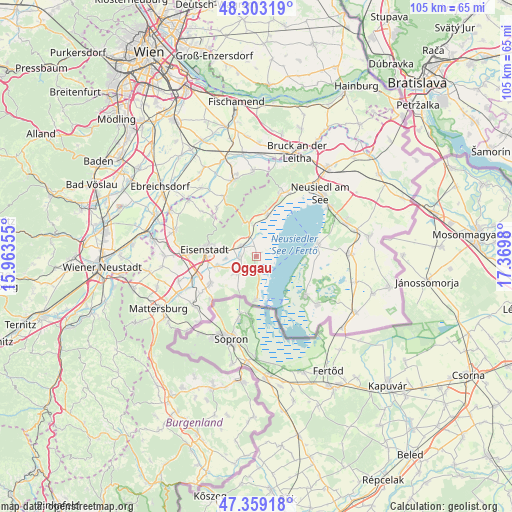
Oggau GPS coordinates[2]
47° 49' 59.988" North, 16° 40' 0.012" East
| Map corner | latitude | longitude |
|---|---|---|
| Upper-left | 48.30319°, | 15.96355° |
| Center: | 47.83333°, | 16.66667° |
| Lower-right: | 47.35918°, | 17.3698° |
| Map W x H: | 105×105 km | = 65.2×65.2mi |
| max Lat: | 48.98333° ⇑41.9% North |
| Oggau: | 47.83333° |
| min Lat: | ⇓58.1% South 46.48841° |
| min Long | Oggau | max Long |
| 9.57802° | 16.66667° | 17.1° |
| W 96.9%⇐ | ⇒3.1% E |
Elevation
Elevation of Oggau is 121 m = 397 ft, and this is 384.5 m = 1261 ft below average elevation for this country.
| Max E: |
2140 m = 7021 ft | 99.8% |
| Avg. | 505.5 m = 1658 ft | |
| Oggau | 121 m = 397 ft | |
Min E: |
118 m = 387 ft | 0.2% |
See also: Austria elevation on elevation.city.
Geographical zone
Oggau is located in North temperate zone (between Tropic of Cancer and the Arctic Circle). Distance of this North polar circle is 2082.6 km =1294.1 mi to North.| Distance of | km | miles | from Oggau |
|---|---|---|---|
| North Pole | 4688.5 | 2913.3 | to North |
| Arctic Circle | 2082.6 | 1294.1 | to North |
| Tropic Cancer | 2712.6 | 1685.5 | to South |
| Equator | 5318.6 | 3304.8 | to South |


Nearby cities:
15 places around Oggau: (largest is in red/bold)
• Donnerskirchen
6.9 km =4.3 mi,  347°
347°
• Eisenstadt
10.8 km =6.7 mi,  277°
277°
• Illmitz
12.8 km =8 mi,  128°
128°
• Kleinhöflein im Burgenland
12.2 km =7.6 mi,  274°
274°
• Mörbisch am See
9.3 km =5.8 mi,  180°
180°
• Oslip
3.5 km =2.2 mi,  262°
262°
• Purbach am Neusiedler See
9.1 km =5.7 mi,  13°
13°
• Rust
3.6 km =2.2 mi,  174°
174°
• Sankt Georgen am Leithagebirge
8.9 km =5.5 mi, 282°
• Sankt Margarethen im Burgenland
5.5 km =3.4 mi,  232°
232°
• Schützen am Gebirge
3.9 km =2.4 mi,  303°
303°
• Siegendorf im Burgenland
11 km =6.8 mi,  237°
237°
• Stotzing
12.2 km =7.6 mi,  312°
312°
• Trausdorf an der Wulka
8.4 km =5.2 mi,  254°
254°
• Wulkaprodersdorf
12.7 km =7.9 mi, 251°
Sources, notices
• [Note1] Compared only with cities in Austria existing in our database
• [Src1] Map data: © OpenStreetMap contributors (CC-BY-SA)
• [Src2] Other city data from geonames.org with taken over terms of usage.
• [Src3] Geographical zone / Annual Mean Temperature by Robert A. Rohde @ Wikipedia
