Oslip geodata
Oslip (Burgenland) is a seat of a third-order administrative division; located in Austria in Europe/Vienna (GMT+2) time zone. With population of 1,243 people, there are 1012 cities with bigger population in this country. Compared to other cities in Austria, 57.9% of cities are located further ↓South; 96.2% of cities are located further ←West and 99.3% of cities have higher elevation than Oslip. Note1


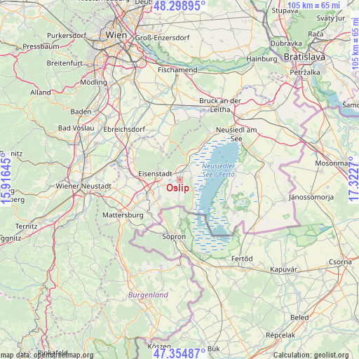
Oslip GPS coordinates[2]
47° 49' 44.616" North, 16° 37' 10.452" East
| Map corner | latitude | longitude |
|---|---|---|
| Upper-left | 48.29895°, | 15.91645° |
| Center: | 47.82906°, | 16.61957° |
| Lower-right: | 47.35487°, | 17.3227° |
| Map W x H: | 105×105 km | = 65.2×65.2mi |
| max Lat: | 48.98333° ⇑42.1% North |
| Oslip: | 47.82906° |
| min Lat: | ⇓57.9% South 46.48841° |
| min Long | Oslip | max Long |
| 9.57802° | 16.61957° | 17.1° |
| W 96.2%⇐ | ⇒3.8% E |
Elevation
Elevation of Oslip is 133 m = 436 ft, and this is 372.5 m = 1222 ft below average elevation for this country.
| Max E: |
2140 m = 7021 ft | 99.3% |
| Avg. | 505.5 m = 1658 ft | |
| Oslip | 133 m = 436 ft | |
Min E: |
118 m = 387 ft | 0.7% |
See also: Austria elevation on elevation.city.
Geographical zone
Oslip is located in North temperate zone (between Tropic of Cancer and the Arctic Circle). Distance of this North polar circle is 2083.1 km =1294.4 mi to North.| Distance of | km | miles | from Oslip |
|---|---|---|---|
| North Pole | 4689 | 2913.6 | to North |
| Arctic Circle | 2083.1 | 1294.4 | to North |
| Tropic Cancer | 2712.2 | 1685.3 | to South |
| Equator | 5318.1 | 3304.5 | to South |


Nearby cities:
15 places around Oslip: (largest is in red/bold)
• Donnerskirchen
7.5 km =4.7 mi,  15°
15°
• Eisenstadt
7.4 km =4.6 mi,  284°
284°
• Grosshöflein
10.4 km =6.5 mi,  274°
274°
• Kleinhöflein im Burgenland
8.7 km =5.4 mi, 279°
• Klingenbach
10.4 km =6.5 mi,  214°
214°
• Mörbisch am See
9.5 km =5.9 mi,  158°
158°
• Oggau
3.5 km =2.2 mi,  82°
82°
• Rust
5 km =3.1 mi,  128°
128°
• Sankt Georgen am Leithagebirge
5.7 km =3.5 mi,  294°
294°
• Sankt Margarethen im Burgenland
3 km =1.9 mi,  195°
195°
• Schützen am Gebirge
2.6 km =1.6 mi,  6°
6°
• Siegendorf im Burgenland
7.9 km =4.9 mi,  227°
227°
• Stotzing
10.3 km =6.4 mi,  327°
327°
• Trausdorf an der Wulka
4.9 km =3 mi,  249°
249°
• Wulkaprodersdorf
9.3 km =5.8 mi, 247°
Sources, notices
• [Note1] Compared only with cities in Austria existing in our database
• [Src1] Map data: © OpenStreetMap contributors (CC-BY-SA)
• [Src2] Other city data from geonames.org with taken over terms of usage.
• [Src3] Geographical zone / Annual Mean Temperature by Robert A. Rohde @ Wikipedia
