Wulkaprodersdorf geodata
Wulkaprodersdorf (Burgenland) is a seat of a third-order administrative division; located in Austria in Europe/Vienna (GMT+2) time zone. With population of 1,944 people, there are 631 cities with bigger population in this country. Compared to other cities in Austria, 56.9% of cities are located further ↓South; 94% of cities are located further ←West and 96.6% of cities have higher elevation than Wulkaprodersdorf. Note1
Administrative division(s):
- Level 1: Burgenland
- Level 2: Eisenstadt-Umgebung
- Level 3: Wulkaprodersdorf


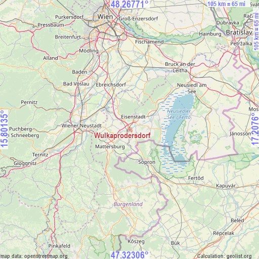
Wulkaprodersdorf GPS coordinates[2]
47° 47' 51.108" North, 16° 30' 16.092" East
| Map corner | latitude | longitude |
|---|---|---|
| Upper-left | 48.26771°, | 15.80135° |
| Center: | 47.79753°, | 16.50447° |
| Lower-right: | 47.32306°, | 17.2076° |
| Map W x H: | 105×105 km | = 65.2×65.2mi |
| max Lat: | 48.98333° ⇑43.1% North |
| Wulkaprodersdorf: | 47.79753° |
| min Lat: | ⇓56.9% South 46.48841° |
| min Long | Wulkaprodersdor | max Long |
| 9.57802° | 16.50447° | 17.1° |
| W 94%⇐ | ⇒6% E |
Elevation
Elevation of Wulkaprodersdorf is 167 m = 548 ft, and this is 338.5 m = 1111 ft below average elevation for this country.
| Max E: |
2140 m = 7021 ft | 96.6% |
| Avg. | 505.5 m = 1658 ft | |
| Wulkaprodersdorf | 167 m = 548 ft | |
Min E: |
118 m = 387 ft | 3.4% |
See also: Austria elevation on elevation.city.
Geographical zone
Wulkaprodersdorf is located in North temperate zone (between Tropic of Cancer and the Arctic Circle). Distance of this North polar circle is 2086.6 km =1296.6 mi to North.| Distance of | km | miles | from Wulkaprodersdorf |
|---|---|---|---|
| North Pole | 4692.5 | 2915.8 | to North |
| Arctic Circle | 2086.6 | 1296.6 | to North |
| Tropic Cancer | 2708.7 | 1683.1 | to South |
| Equator | 5314.6 | 3302.3 | to South |


Nearby cities:
15 places around Wulkaprodersdorf: (largest is in red/bold)
• Antau
3.2 km =2 mi,  214°
214°
• Baumgarten im Burgenland
6.5 km =4 mi,  182°
182°
• Drassburg
5.8 km =3.6 mi,  193°
193°
• Eisenstadt
5.5 km =3.4 mi,  14°
14°
• Grosshöflein
4.6 km =2.9 mi,  337°
337°
• Hirm
3.9 km =2.4 mi,  251°
251°
• Kleinhöflein im Burgenland
4.9 km =3 mi,  359°
359°
• Klingenbach
5.7 km =3.5 mi,  151°
151°
• Müllendorf
5.6 km =3.5 mi,  326°
326°
• Sankt Georgen am Leithagebirge
6.8 km =4.2 mi,  30°
30°
• Siegendorf im Burgenland
3.4 km =2.1 mi,  123°
123°
• Stöttera
4.6 km =2.9 mi,  224°
224°
• Trausdorf an der Wulka
4.3 km =2.7 mi,  65°
65°
• Zagersdorf
3.7 km =2.3 mi,  169°
169°
• Zemendorf
5.6 km =3.5 mi,  225°
225°
Sources, notices
• [Note1] Compared only with cities in Austria existing in our database
• [Src1] Map data: © OpenStreetMap contributors (CC-BY-SA)
• [Src2] Other city data from geonames.org with taken over terms of usage.
• [Src3] Geographical zone / Annual Mean Temperature by Robert A. Rohde @ Wikipedia
