Mühlen geodata
Mühlen (Styria) is a seat of a third-order administrative division; located in Austria in Europe/Vienna (GMT+2) time zone. With population of 295 people, there are 2753 cities with bigger population in this country. Compared to other cities in Austria, 82.9% of cities are located further ↑North; 53% of cities are located further →East and 93% of cities have lower elevation than Mühlen. Note1


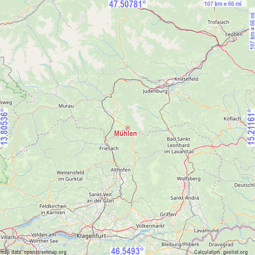
Mühlen GPS coordinates[2]
47° 1' 50.556" North, 14° 30' 30.528" East
| Map corner | latitude | longitude |
|---|---|---|
| Upper-left | 47.50781°, | 13.80536° |
| Center: | 47.03071°, | 14.50848° |
| Lower-right: | 46.5493°, | 15.21161° |
| Map W x H: | 106.6×106.6 km | = 66.2×66.2mi |
| max Lat: | 48.98333° ⇑82.9% North |
| Mühlen: | 47.03071° |
| min Lat: | ⇓17.1% South 46.48841° |
| min Long | Mühlen | max Long |
| 9.57802° | 14.50848° | 17.1° |
| W 47%⇐ | ⇒53% E |
Elevation
Elevation of Mühlen is 960 m = 3150 ft, and this is 454.5 m = 1491 ft above average elevation for this country.
| Max E: |
2140 m = 7021 ft | 7% |
| Mühlen | 960 m 3150 ft | |
| Avg. | 505.5 m = 1658 ft | |
Min E: |
118 m = 387 ft | 93% |
See also: Austria elevation on elevation.city.
Geographical zone
Mühlen is located in North temperate zone (between Tropic of Cancer and the Arctic Circle). Distance of this North polar circle is 2171.8 km =1349.5 mi to North.| Distance of | km | miles | from Mühlen |
|---|---|---|---|
| North Pole | 4777.7 | 2968.7 | to North |
| Arctic Circle | 2171.8 | 1349.5 | to North |
| Tropic Cancer | 2623.4 | 1630.1 | to South |
| Equator | 5229.3 | 3249.3 | to South |


Nearby cities:
15 places around Mühlen: (largest is in red/bold)
• Dürnstein in der Steiermark
10 km =6.2 mi,  241°
241°
• Friesach
11.4 km =7.1 mi,  222°
222°
• Hüttenberg
10.4 km =6.5 mi,  162°
162°
• Kulm am Zirbitz
3.5 km =2.2 mi,  331°
331°
• Mariahof
11.3 km =7 mi,  313°
313°
• Micheldorf
14.5 km =9 mi,  208°
208°
• Micheldorf in Kärnten
14.3 km =8.9 mi, 205°
• Neumarkt in Steiermark
7.8 km =4.8 mi, 308°
• Obdach
13.8 km =8.6 mi,  73°
73°
• Perchau am Sattel
8.9 km =5.5 mi, 330°
• Sankt Georgen bei Neumarkt
6.3 km =3.9 mi, 308°
• Sankt Lorenzen bei Scheifling
14.9 km =9.3 mi, 328°
• Sankt Marein bei Neumarkt
7.2 km =4.5 mi,  303°
303°
• Sankt Salvator
13.3 km =8.3 mi, 239°
• Zeutschach
11.5 km =7.1 mi,  290°
290°
Sources, notices
• [Note1] Compared only with cities in Austria existing in our database
• [Src1] Map data: © OpenStreetMap contributors (CC-BY-SA)
• [Src2] Other city data from geonames.org with taken over terms of usage.
• [Src3] Geographical zone / Annual Mean Temperature by Robert A. Rohde @ Wikipedia
