Mortantsch geodata
Mortantsch (Styria) is a seat of a third-order administrative division; located in Austria in Europe/Vienna (GMT+2) time zone. With population of 191 people, there are 2860 cities with bigger population in this country. Compared to other cities in Austria, 71.9% of cities are located further ↑North; 67.9% of cities are located further ←West and 55.2% of cities have lower elevation than Mortantsch. Note1


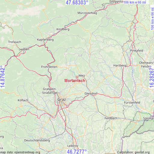
Mortantsch GPS coordinates[2]
47° 12' 27.072" North, 15° 34' 46.344" East
| Map corner | latitude | longitude |
|---|---|---|
| Upper-left | 47.68303°, | 14.87642° |
| Center: | 47.20752°, | 15.57954° |
| Lower-right: | 46.7277°, | 16.28267° |
| Map W x H: | 106.2×106.2 km | = 66×66mi |
| max Lat: | 48.98333° ⇑71.9% North |
| Mortantsch: | 47.20752° |
| min Lat: | ⇓28.1% South 46.48841° |
| min Long | Mortantsch | max Long |
| 9.57802° | 15.57954° | 17.1° |
| W 67.9%⇐ | ⇒32.1% E |
Elevation
Elevation of Mortantsch is 486 m = 1594 ft, and this is 19.5 m = 64 ft below average elevation for this country.
| Max E: |
2140 m = 7021 ft | 44.8% |
| Avg. | 505.5 m = 1658 ft | |
| Mortantsch | 486 m = 1594 ft | |
Min E: |
118 m = 387 ft | 55.2% |
See also: Austria elevation on elevation.city.
Geographical zone
Mortantsch is located in North temperate zone (between Tropic of Cancer and the Arctic Circle). Distance of this North polar circle is 2152.2 km =1337.3 mi to North.| Distance of | km | miles | from Mortantsch |
|---|---|---|---|
| North Pole | 4758.1 | 2956.5 | to North |
| Arctic Circle | 2152.2 | 1337.3 | to North |
| Tropic Cancer | 2643.1 | 1642.3 | to South |
| Equator | 5249 | 3261.6 | to South |


Nearby cities:
15 places around Mortantsch: (largest is in red/bold)
• Affental
3.7 km =2.3 mi,  8°
8°
• Arzberg
6.7 km =4.2 mi,  314°
314°
• Gschwendt
3.3 km =2.1 mi,  189°
189°
• Göttelsberg
1.9 km =1.2 mi,  56°
56°
• Kleinsemmering
2 km =1.2 mi, 188°
• Krottendorf
4.1 km =2.5 mi,  101°
101°
• Kumberg
6 km =3.7 mi,  216°
216°
• Landscha bei Weiz
3 km =1.9 mi,  70°
70°
• Mitterdorf an der Raab
4.8 km =3 mi,  161°
161°
• Naas
4.9 km =3 mi, 13°
• Preding
6 km =3.7 mi,  116°
116°
• Sankt Radegund bei Graz
7.2 km =4.5 mi,  246°
246°
• Stenzengreith
4.8 km =3 mi,  260°
260°
• Unterfladnitz
7.1 km =4.4 mi,  112°
112°
• Weiz
3 km =1.9 mi, 70°
Sources, notices
• [Note1] Compared only with cities in Austria existing in our database
• [Src1] Map data: © OpenStreetMap contributors (CC-BY-SA)
• [Src2] Other city data from geonames.org with taken over terms of usage.
• [Src3] Geographical zone / Annual Mean Temperature by Robert A. Rohde @ Wikipedia
