Liebenau geodata
Liebenau (Styria) is a section of populated place; located in Austria in Europe/Vienna (GMT+2) time zone. With population of 14,447 people, there are 49 cities with bigger population in this country. Compared to other cities in Austria, 82.8% of cities are located further ↑North; 64.4% of cities are located further ←West and 66.6% of cities have higher elevation than Liebenau. Note1


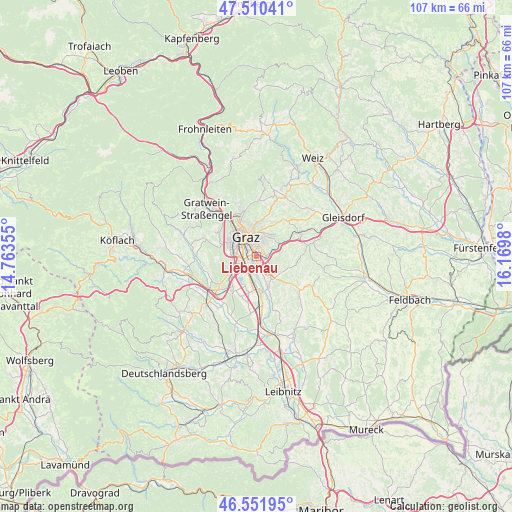
Liebenau GPS coordinates[2]
47° 1' 59.988" North, 15° 28' 0.012" East
| Map corner | latitude | longitude |
|---|---|---|
| Upper-left | 47.51041°, | 14.76355° |
| Center: | 47.03333°, | 15.46667° |
| Lower-right: | 46.55195°, | 16.1698° |
| Map W x H: | 106.6×106.6 km | = 66.2×66.2mi |
| max Lat: | 48.98333° ⇑82.8% North |
| Liebenau: | 47.03333° |
| min Lat: | ⇓17.2% South 46.48841° |
| min Long | Liebenau | max Long |
| 9.57802° | 15.46667° | 17.1° |
| W 64.4%⇐ | ⇒35.6% E |
Elevation
Elevation of Liebenau is 344 m = 1129 ft, and this is 161.5 m = 530 ft below average elevation for this country.
| Max E: |
2140 m = 7021 ft | 66.6% |
| Avg. | 505.5 m = 1658 ft | |
| Liebenau | 344 m = 1129 ft | |
Min E: |
118 m = 387 ft | 33.4% |
See also: Austria elevation on elevation.city.
Geographical zone
Liebenau is located in North temperate zone (between Tropic of Cancer and the Arctic Circle). Distance of this North polar circle is 2171.6 km =1349.4 mi to North.| Distance of | km | miles | from Liebenau |
|---|---|---|---|
| North Pole | 4777.4 | 2968.5 | to North |
| Arctic Circle | 2171.6 | 1349.4 | to North |
| Tropic Cancer | 2623.7 | 1630.3 | to South |
| Equator | 5229.6 | 3249.5 | to South |


Nearby cities:
15 places around Liebenau: (largest is in red/bold)
• Abtissendorf
4.2 km =2.6 mi,  190°
190°
• Dörfla
3.7 km =2.3 mi,  180°
180°
• Feldkirchen bei Graz
2.2 km =1.4 mi,  214°
214°
• Grambach
3.5 km =2.2 mi,  126°
126°
• Graz
3.9 km =2.4 mi,  341°
341°
• Gössendorf
4.2 km =2.6 mi,  159°
159°
• Hart bei Graz
3.8 km =2.4 mi,  73°
73°
• Jakomini
2.7 km =1.7 mi,  331°
331°
• Lebern
3.9 km =2.4 mi,  198°
198°
• Puntigam
2.5 km =1.6 mi,  270°
270°
• Raaba
2.5 km =1.6 mi,  90°
90°
• Sankt Leonhard
4 km =2.5 mi,  350°
350°
• Sankt Peter
1.9 km =1.2 mi,  0°
0°
• Thondorf
2.6 km =1.6 mi,  165°
165°
• Waltendorf
3.7 km =2.3 mi, 0°
Sources, notices
• [Note1] Compared only with cities in Austria existing in our database
• [Src1] Map data: © OpenStreetMap contributors (CC-BY-SA)
• [Src2] Other city data from geonames.org with taken over terms of usage.
• [Src3] Geographical zone / Annual Mean Temperature by Robert A. Rohde @ Wikipedia
