Lassing geodata
Lassing (Styria) is a seat of a third-order administrative division; located in Austria in Europe/Vienna (GMT+2) time zone. In our database, there are 2958 cities with bigger population. Compared to other cities in Austria, 52% of cities are located further ↑North; 59.1% of cities are located further →East and 81% of cities have lower elevation than Lassing. Note1


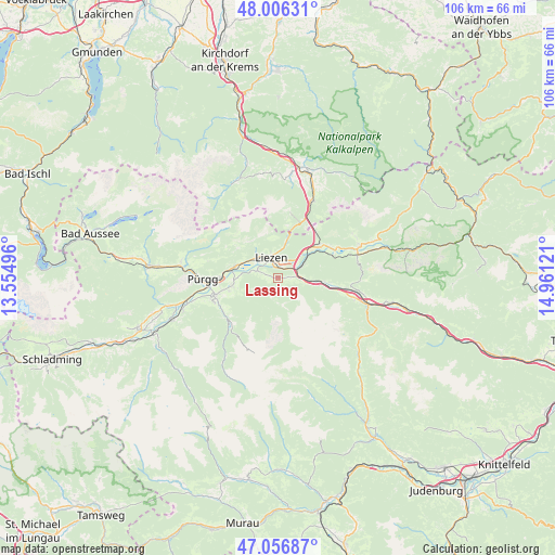
Lassing GPS coordinates[2]
47° 32' 1.464" North, 14° 15' 29.088" East
| Map corner | latitude | longitude |
|---|---|---|
| Upper-left | 48.00631°, | 13.55496° |
| Center: | 47.53374°, | 14.25808° |
| Lower-right: | 47.05687°, | 14.96121° |
| Map W x H: | 105.6×105.6 km | = 65.6×65.6mi |
| max Lat: | 48.98333° ⇑52% North |
| Lassing: | 47.53374° |
| min Lat: | ⇓48% South 46.48841° |
| min Long | Lassing | max Long |
| 9.57802° | 14.25808° | 17.1° |
| W 40.9%⇐ | ⇒59.1% E |
Elevation
Elevation of Lassing is 735 m = 2411 ft, and this is 229.5 m = 753 ft above average elevation for this country.
| Max E: |
2140 m = 7021 ft | 19% |
| Lassing | 735 m 2411 ft | |
| Avg. | 505.5 m = 1658 ft | |
Min E: |
118 m = 387 ft | 81% |
See also: Austria elevation on elevation.city.
Geographical zone
Lassing is located in North temperate zone (between Tropic of Cancer and the Arctic Circle). Distance of this North polar circle is 2115.9 km =1314.8 mi to North.| Distance of | km | miles | from Lassing |
|---|---|---|---|
| North Pole | 4721.8 | 2934 | to North |
| Arctic Circle | 2115.9 | 1314.8 | to North |
| Tropic Cancer | 2679.3 | 1664.8 | to South |
| Equator | 5285.3 | 3284.1 | to South |


Nearby cities:
15 places around Lassing: (largest is in red/bold)
• Aigen im Ennstal
9.6 km =6 mi,  258°
258°
• Ardning
10.2 km =6.3 mi,  51°
51°
• Boder
8.2 km =5.1 mi,  90°
90°
• Bruckmühl
5.6 km =3.5 mi, 90°
• Donnersbach
12.6 km =7.8 mi,  230°
230°
• Falkenburg
13.6 km =8.5 mi,  254°
254°
• Irdning
12.2 km =7.6 mi, 254°
• Klausner
8.3 km =5.2 mi,  56°
56°
• Liezen
4.1 km =2.5 mi,  333°
333°
• Oppenberg
5.6 km =3.5 mi,  173°
173°
• Rottenmann
7.2 km =4.5 mi,  105°
105°
• Selzthal
4.4 km =2.7 mi,  66°
66°
• Stainach
11.2 km =7 mi,  269°
269°
• Weißenbach bei Liezen
4.8 km =3 mi,  319°
319°
• Wörschach
8.3 km =5.2 mi,  282°
282°
Sources, notices
• [Note1] Compared only with cities in Austria existing in our database
• [Src1] Map data: © OpenStreetMap contributors (CC-BY-SA)
• [Src2] Other city data from geonames.org with taken over terms of usage.
• [Src3] Geographical zone / Annual Mean Temperature by Robert A. Rohde @ Wikipedia
