Krakauhintermühlen geodata
Krakauhintermühlen (Styria) is a seat of a third-order administrative division; located in Austria in Europe/Vienna (GMT+2) time zone. With population of 517 people, there are 2442 cities with bigger population in this country. Compared to other cities in Austria, 74.1% of cities are located further ↑North; 65.3% of cities are located further →East and 97.5% of cities have lower elevation than Krakauhintermühlen. Note1


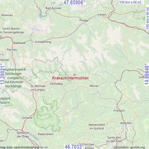
Krakauhintermühlen GPS coordinates[2]
47° 10' 59.988" North, 13° 58' 59.988" East
| Map corner | latitude | longitude |
|---|---|---|
| Upper-left | 47.65906°, | 13.28021° |
| Center: | 47.18333°, | 13.98333° |
| Lower-right: | 46.7033°, | 14.68646° |
| Map W x H: | 106.3×106.3 km | = 66.1×66.1mi |
| max Lat: | 48.98333° ⇑74.1% North |
| Krakauhintermühlen: | 47.18333° |
| min Lat: | ⇓25.9% South 46.48841° |
| min Long | Krakauhintermü | max Long |
| 9.57802° | 13.98333° | 17.1° |
| W 34.7%⇐ | ⇒65.3% E |
Elevation
Elevation of Krakauhintermühlen is 1161 m = 3809 ft, and this is 655.5 m = 2151 ft above average elevation for this country.
| Max E: |
2140 m = 7021 ft | 2.5% |
| Krakauhintermühlen | 1161 m 3809 ft | |
| Avg. | 505.5 m = 1658 ft | |
Min E: |
118 m = 387 ft | 97.5% |
See also: Austria elevation on elevation.city.
Geographical zone
Krakauhintermühlen is located in North temperate zone (between Tropic of Cancer and the Arctic Circle). Distance of this North polar circle is 2154.9 km =1339 mi to North.| Distance of | km | miles | from Krakauhintermühlen |
|---|---|---|---|
| North Pole | 4760.8 | 2958.2 | to North |
| Arctic Circle | 2154.9 | 1339 | to North |
| Tropic Cancer | 2640.4 | 1640.7 | to South |
| Equator | 5246.3 | 3259.9 | to South |


Nearby cities:
15 places around Krakauhintermühlen: (largest is in red/bold)
• Krakaudorf
2.8 km =1.7 mi,  94°
94°
• Krakauschatten
1.3 km =0.8 mi,  270°
270°
• Murau
16.2 km =10.1 mi,  119°
119°
• Mörtelsdorf
15.9 km =9.9 mi,  247°
247°
• Ramingstein
16.4 km =10.2 mi,  222°
222°
• Ranten
8 km =5 mi,  109°
109°
• Sankt Andrä im Lungau
15.6 km =9.7 mi,  256°
256°
• Sankt Georgen ob Murau
12.8 km =8 mi,  136°
136°
• Sankt Lorenzen ob Murau
12.8 km =8 mi, 138°
• Sankt Nikolai im Sölktal
15.7 km =9.8 mi,  18°
18°
• Sankt Peter am Kammersberg
15.2 km =9.4 mi, 88°
• Schöder
8.8 km =5.5 mi, 90°
• St. Ruprecht-Falkendorf
9.5 km =5.9 mi,  164°
164°
• Stadl an der Mur
11.2 km =7 mi,  186°
186°
• Tamsweg
14.4 km =8.9 mi,  244°
244°
Sources, notices
• [Note1] Compared only with cities in Austria existing in our database
• [Src1] Map data: © OpenStreetMap contributors (CC-BY-SA)
• [Src2] Other city data from geonames.org with taken over terms of usage.
• [Src3] Geographical zone / Annual Mean Temperature by Robert A. Rohde @ Wikipedia
